IMAGES TAKEN NEAR TO
Parc Cemlyn, PRESTATYN, LL19 9NX
Introduction
This page details the photographs taken nearby to Parc Cemlyn, LL19 9NX by members of the Geograph project.
The Geograph project started in 2005 with the aim of publishing, organising and preserving representative images for every square kilometre of Great Britain, Ireland and the Isle of Man.

There are currently over 7.5m images from over14,400 individuals and you can help contribute to the project by visiting https://www.geograph.org.uk
Image Map
Images are licensed for reuse under creativecommons.org/licenses/by-sa/2.0
Notes
- Clicking on the map will re-center to the selected point.
- The higher the marker number, the further away the image location is from the centre of the postcode.
Image Listing (113 Images Found)
Images are licensed for reuse under creativecommons.org/licenses/by-sa/2.0
Image
Details
Distance
2
Ysgol Bodnant, Prestatyn
Junior school on the eastern fringes of Prestatyn.
Image: © Eirian Evans
Taken: 11 Jan 2008
0.09 miles
4
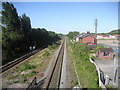
Railway heading East out of Prestatyn
Taken from the pedestrian railway bridge by Prestatyn Station, his looks east down the line towards Flintshire.
Image: © Chris Heaton
Taken: 12 May 2009
0.10 miles
5
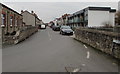
Caradoc Road, Prestatyn
From the corner of Morley Road. Tŷ Caradoc Community Centre http://www.geograph.org.uk/photo/5277757 is on the left.
Image: © Jaggery
Taken: 9 Feb 2017
0.10 miles

7
Tŷ Caradoc Community Centre, Prestatyn
On the corner of Morley Road and Caradoc Road.
Image: © Jaggery
Taken: 9 Feb 2017
0.14 miles
8
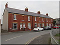
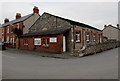
Row of brick houses, Morley Road, Prestatyn
Located between Station Road and Caradoc Road, these houses are opposite Coronation Gardens.
Image: © Jaggery
Taken: 9 Feb 2017
0.15 miles
9
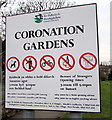
Activities banned in Coronation Gardens, Prestatyn
The notice at an entrance to these http://www.geograph.org.uk/photo/5277952 gardens indicates
No Dog Fouling, No Litter, No Cycling, No Alcohol, No Fly Tipping.
The notice also states Beware of Strangers. The text is also in Welsh.
Image: © Jaggery
Taken: 9 Feb 2017
0.15 miles
10
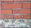
Ordnance Survey Cut Mark
This OS cut mark can be found on the wall of No2 Mostyn Road. It marks a point 11.902m above mean sea level.
Image: © Adrian Dust
Taken: 15 Sep 2019
0.15 miles