IMAGES TAKEN NEAR TO
Nant Hall Road, PRESTATYN, LL19 9LP
Introduction
This page details the photographs taken nearby to Nant Hall Road, LL19 9LP by members of the Geograph project.
The Geograph project started in 2005 with the aim of publishing, organising and preserving representative images for every square kilometre of Great Britain, Ireland and the Isle of Man.

There are currently over 7.5m images from over14,400 individuals and you can help contribute to the project by visiting https://www.geograph.org.uk
Image Map (Loading...)


Getting Data...Please wait
Leaflet Map data © OpenStreetMap
Images are licensed for reuse under creativecommons.org/licenses/by-sa/2.0
Notes
- Clicking on the map will re-center to the selected point.
- The higher the marker number, the further away the image location is from the centre of the postcode.
Image Listing (14 Images Found)
Images are licensed for reuse under creativecommons.org/licenses/by-sa/2.0
Image
Details
Distance
2
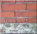
Ordnance Survey Cut Mark
This OS cut mark can be found on the wall of No2 Mostyn Road. It marks a point 11.902m above mean sea level.
Image: © Adrian Dust
Taken: 15 Sep 2019
0.08 miles
3
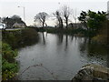
Nant Mill Pool
Once a millpond, now a duck pond near the end of Nant Hall Road in Prestatyn. The mill and its pond were here in the twelfth century.
Image: © Eirian Evans
Taken: 11 Jan 2008
0.10 miles
4
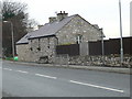
Converted barn, Prestatyn
The house is adjacent to Nant Mill pond. A mounting block is attached.
Image: © Eirian Evans
Taken: 11 Jan 2008
0.10 miles
5
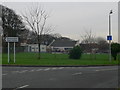
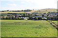
Ysgol Bodnant, Prestatyn
Junior school on the eastern fringes of Prestatyn.
Image: © Eirian Evans
Taken: 11 Jan 2008
0.15 miles
6
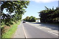
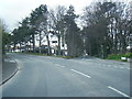
The A548 (Prestatyn Road)
The A548 (Prestatyn Road) heading east on the outskirts of Prestatyn.
Image: © Jeff Buck
Taken: 7 Sep 2015
0.18 miles
7
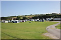
Nant Mill Family Touring Park, Prestatyn
The Nant Mill Family Touring Park on the A548 (Prestatyn Road) on the outskirts of Prestatyn.
Image: © Jeff Buck
Taken: 7 Sep 2015
0.20 miles
8
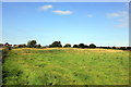
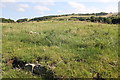
Prestatyn Castle (Motte and Bailey)
The motte seen from the south. Prestatyn was granted to Robert de Banastre by King Henry II in 1165. The castle, which was destroyed by Owain Gwynedd in 1167 does not appear to have been rebuilt. After the castle was destroyed the Banastre family fled to Lancashire.
*Source: Wikipedia
Image: © Jeff Buck
Taken: 7 Sep 2015
0.20 miles
9
Prestatyn Castle (Motte and Bailey)
The best view of what remains of Prestatyn Castle motte and bailey can be seen from the footbridge over the North Wales Coast Line. Prestatyn was granted to Robert de Banastre by King Henry II in 1165. The castle, which was destroyed by Owain Gwynedd in 1167 does not appear to have been rebuilt. After the castle was destroyed the Banastre family fled to Lancashire.
*Source: Wikipedia
Image: © Jeff Buck
Taken: 7 Sep 2015
0.20 miles
10
Prestatyn Castle (Motte and Bailey)
Some of the remaining stones of Prestatyn Castle can be seen below the Motte to the north. Prestatyn was granted to Robert de Banastre by King Henry II in 1165. The castle, which was destroyed by Owain Gwynedd in 1167 does not appear to have been rebuilt. After the castle was destroyed the Banastre family fled to Lancashire.
*Source: Wikipedia
Image: © Jeff Buck
Taken: 7 Sep 2015
0.21 miles