IMAGES TAKEN NEAR TO
East Avenue, PRESTATYN, LL19 9ES
Introduction
This page details the photographs taken nearby to East Avenue, LL19 9ES by members of the Geograph project.
The Geograph project started in 2005 with the aim of publishing, organising and preserving representative images for every square kilometre of Great Britain, Ireland and the Isle of Man.

There are currently over 7.5m images from over14,400 individuals and you can help contribute to the project by visiting https://www.geograph.org.uk
Image Map
Images are licensed for reuse under creativecommons.org/licenses/by-sa/2.0
Notes
- Clicking on the map will re-center to the selected point.
- The higher the marker number, the further away the image location is from the centre of the postcode.
Image Listing (5 Images Found)
Images are licensed for reuse under creativecommons.org/licenses/by-sa/2.0
Image
Details
Distance
1
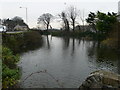
Nant Mill Pool
Once a millpond, now a duck pond near the end of Nant Hall Road in Prestatyn. The mill and its pond were here in the twelfth century.
Image: © Eirian Evans
Taken: 11 Jan 2008
0.15 miles
2
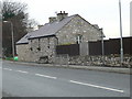
Converted barn, Prestatyn
The house is adjacent to Nant Mill pond. A mounting block is attached.
Image: © Eirian Evans
Taken: 11 Jan 2008
0.15 miles
4
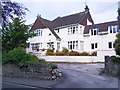
Quality housing in Upper Prestatyn
The better quality housing in Prestatyn is found higher up the hill.
Image: © David and Rachel Landin
Taken: 31 Jul 2005
0.20 miles
5
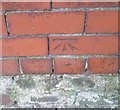
Ordnance Survey Cut Mark
This OS cut mark can be found on the wall of No2 Mostyn Road. It marks a point 11.902m above mean sea level.
Image: © Adrian Dust
Taken: 15 Sep 2019
0.23 miles