IMAGES TAKEN NEAR TO
High Street, PRESTATYN, LL19 9AU
Introduction
This page details the photographs taken nearby to High Street, LL19 9AU by members of the Geograph project.
The Geograph project started in 2005 with the aim of publishing, organising and preserving representative images for every square kilometre of Great Britain, Ireland and the Isle of Man.

There are currently over 7.5m images from over14,400 individuals and you can help contribute to the project by visiting https://www.geograph.org.uk
Image Map
Images are licensed for reuse under creativecommons.org/licenses/by-sa/2.0
Notes
- Clicking on the map will re-center to the selected point.
- The higher the marker number, the further away the image location is from the centre of the postcode.
Image Listing (118 Images Found)
Images are licensed for reuse under creativecommons.org/licenses/by-sa/2.0
Image
Details
Distance
1
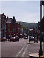
Prestatyn High Street
One way system, looking up towards the hills.
Sadly no more Woolworths on the right.
Image: © Peter Teal
Taken: 9 Sep 2008
0.01 miles
2
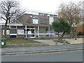
Prestatyn Library
The Library is in Prestatyn on Nant Hall Road, near the Council Offices. The mural on the right depicts Offa, as Offa's Dyke was said to commence near Prestatyn.
Image: © Eirian Evans
Taken: 11 Jan 2008
0.02 miles
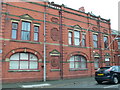
3
Ty Nant, Prestatyn
Denbighshire County Council has no central offices - directorates are spread throughout the County and here in Prestatyn is the headquarters of the Social Services department. There is also a police counter in this building.
Image: © Eirian Evans
Taken: 11 Jan 2008
0.02 miles
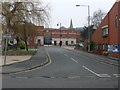
4
Council Offices, Prestatyn
This was the home of Prestatyn Urban District Council, and still houses offices for Prestatyn Town Council. The building was erected in 1903 and also housed the Fire Station.
Image: © Eirian Evans
Taken: 11 Jan 2008
0.02 miles
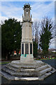
5
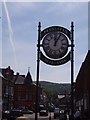
Prestatyn High Street
Commemorative clock, not changed much over the years.
Image: © Peter Teal
Taken: 9 Jun 2006
0.02 miles
6
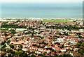
And this is Prestatyn
The last view for Offa's Dyke walkers high above Prestatyn. Here the route to the finish can be traced past the church in the middle right, over the railway line in the centre then positively skip down Ffordd-las, High Street and Bastion Road to dip ones feet in the sea.
Image: © Graham Horn
Taken: 8 Jun 2000
0.03 miles
7
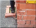
Ordnance Survey Cut Mark
This OS cut mark can be found on the old post office building. It marks a point 7.580m above mean sea level.
Image: © Adrian Dust
Taken: 15 Sep 2019
0.04 miles
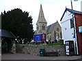
8
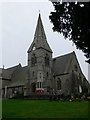
Christ Church, Prestatyn
The parish church for Prestatyn, which dates from 1863
Image: © Eirian Evans
Taken: 13 Jan 2008
0.04 miles
10
Eglwys Crist ym Mhrestatyn / Christ Church in Prestatyn
Eglwys Crist ym Mhrestatyn / Christ Church in Prestatyn
Image: © Ian Medcalf
Taken: 5 Apr 2010
0.05 miles