IMAGES TAKEN NEAR TO
The Grove, PRESTATYN, LL19 8LB
Introduction
This page details the photographs taken nearby to The Grove, LL19 8LB by members of the Geograph project.
The Geograph project started in 2005 with the aim of publishing, organising and preserving representative images for every square kilometre of Great Britain, Ireland and the Isle of Man.

There are currently over 7.5m images from over14,400 individuals and you can help contribute to the project by visiting https://www.geograph.org.uk
Image Map
Images are licensed for reuse under creativecommons.org/licenses/by-sa/2.0
Notes
- Clicking on the map will re-center to the selected point.
- The higher the marker number, the further away the image location is from the centre of the postcode.
Image Listing (12 Images Found)
Images are licensed for reuse under creativecommons.org/licenses/by-sa/2.0
Image
Details
Distance
1
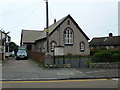
Salem Methodist Chapel, Meliden
Welsh chapel in the middle of Meliden.
Image: © Eirian Evans
Taken: 11 Jan 2008
0.05 miles
2
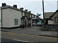
Cottages, Meliden
Cottages next to the Welsh Methodist chapel in Meliden.
Image: © Eirian Evans
Taken: 11 Jan 2008
0.05 miles
3
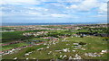
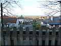
On Graig Fawr - view over Meliden & beyond towards Prestatyn
Image: © Richard Park
Taken: 12 May 2021
0.13 miles
4
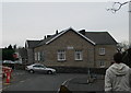
Meliden Masonic Hall
On the cordner of Ffordd Penrhwylfa.
Image: © Eirian Evans
Taken: 11 Jan 2008
0.14 miles
5
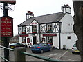
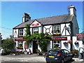
The Red Lion, Meliden
This free house is on the outskirts of Meliden next to the parish church.
Image: © Eirian Evans
Taken: 11 Jan 2008
0.14 miles
6
View over part of Meliden from the old railway trackbed bridge
The elevation here permits a nice view towards the sea.
Image: © Jeremy Bolwell
Taken: 2 Jan 2012
0.16 miles
8
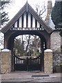
St.Melyn Church, Meliden
The gates to the church of St.Melyn in Meliden, North Wales.
Image: © Dave Pickersgill
Taken: 22 Mar 2008
0.21 miles
9
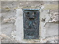
Ordnance Survey Flush Bracket S6278
This bracket can be found on the wall of St Melyd's Church, Meliden. The benchmark height is recorded as being 38.259 metres above sea level.
For more detail see : https://www.bench-marks.org.uk/bm19735
Image: © Peter Wood
Taken: 24 Nov 2018
0.22 miles
10
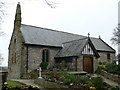
St Melyd, Meliden
Small medieval parish church which has been substantially restored in Victorian times. On the A547.
Image: © Eirian Evans
Taken: 11 Jan 2008
0.23 miles