
IMAGES TAKEN NEAR TO
Maeshyfryd Terrace, RHYL, LL18 6EY
Introduction
This page details the photographs taken nearby to Maeshyfryd Terrace, LL18 6EY by members of the Geograph project.
The Geograph project started in 2005 with the aim of publishing, organising and preserving representative images for every square kilometre of Great Britain, Ireland and the Isle of Man.

There are currently over 7.5m images from over14,400 individuals and you can help contribute to the project by visiting https://www.geograph.org.uk
Image Map
Images are licensed for reuse under creativecommons.org/licenses/by-sa/2.0
Notes
- Clicking on the map will re-center to the selected point.
- The higher the marker number, the further away the image location is from the centre of the postcode.
Image Listing (64 Images Found)
Images are licensed for reuse under creativecommons.org/licenses/by-sa/2.0
Image
Details
Distance
1
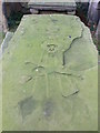
Old grave, Dyserth church
Skull and crossbones on this old grave in Dyserth churchyard.
Image: © Eirian Evans
Taken: 29 Jan 2008
0.05 miles
2

Canopied tomb, Dyserth
Rare Jacobean canopied tomb at Dyserth church. It is dated 1676 and has an angel carved beneath the canopy.
Image: © Eirian Evans
Taken: 29 Jan 2008
0.05 miles
4
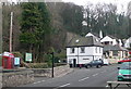
Dyserth Waterfall Shop
The bottom half of this building was opened as a shop and pay booth for the Dyserth waterfall in the 1920's. It has since been enlarged and is now also a cafe.
Image: © Eirian Evans
Taken: 29 Jan 2008
0.05 miles
5
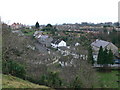
Dyserth
Lower Dyserth as seen from the hill above the waterfall. Bethel chapel (right) is now disused; the small white building behind the trees in the centre is the Waterfall Shop which was once the stables for the pub situated next to Bethel.
Image: © Eirian Evans
Taken: 11 Jan 2008
0.05 miles
6
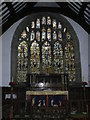
Jesse window, Dyserth Parish Church
The chief glory of this church is the stained glass window above the altar. This has been described as the finest example of a medieval Jesse Window in North Wales. It is basically in two sections. The upper part is a representation of the twelve Apostles and some feel that it is older than the lower section which is the Jesse window - that is the family tree of Christ. Some authorities say that the older part dates from 1430 and the second part resulted from a bequest in 1530. One tradition has it that the glass was originally in the Abbey at Basingwerk.
Image: © Eirian Evans
Taken: 11 Jan 2008
0.07 miles
7

Bethel Chapel on Waterfall Road, Dyserth
Redundant chapel, built in 1823 for the Presbyterians. It is next to the Red Lion Inn. In 1867 William Shipley-Conwy of Bodrhyddan Hall gave some adjoining land so that the chapel could be enlarged. The congregation were so pleased that 300 of them walked to the hall to thank Mr Shipley-Conwy and sang to him on the lawn.
Image: © Eirian Evans
Taken: 11 Jan 2008
0.07 miles
8

Y Llew Coch - The Red Lion, Dyserth
A pub on Waterfall Road, Dyserth.
Image: © Eirian Evans
Taken: 13 Jan 2008
0.07 miles
9

Dyserth waterfall
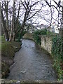
In Lower Dyserth the Afon Ffyddion plunges seventy feet to create the waterfall for which the village is famous. In times of heavy rainfall it can turn into a raging torrent and the stream below has been known to overflow and flood parts of the lower village. Dr Johnson came to see it in 1774.
Image: © Eirian Evans
Taken: 11 Jan 2008
0.07 miles
10
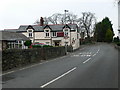
Tafarn Newydd - New Inn, Dyserth
On Waterfall Road, opposite the parish church.
Image: © Eirian Evans
Taken: 11 Jan 2008
0.07 miles