IMAGES TAKEN NEAR TO
Allt Y Graig, RHYL, LL18 6DE
Introduction
This page details the photographs taken nearby to Allt Y Graig, LL18 6DE by members of the Geograph project.
The Geograph project started in 2005 with the aim of publishing, organising and preserving representative images for every square kilometre of Great Britain, Ireland and the Isle of Man.

There are currently over 7.5m images from over14,400 individuals and you can help contribute to the project by visiting https://www.geograph.org.uk
Image Map
Images are licensed for reuse under creativecommons.org/licenses/by-sa/2.0
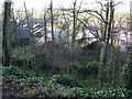
Notes
- Clicking on the map will re-center to the selected point.
- The higher the marker number, the further away the image location is from the centre of the postcode.
Image Listing (30 Images Found)
Images are licensed for reuse under creativecommons.org/licenses/by-sa/2.0
Image
Details
Distance
1
Chalets below Graig Fawr
The chalets are maybe a little too tightly packed in on this site but my first impression may be wrong.
Image: © Jeremy Bolwell
Taken: 2 Jan 2012
0.08 miles
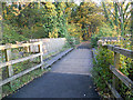
3
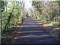
Part of the Prestatyn-Dyserth Way
Ideal for jogging or cycling and also very popular with walkers, dog-walkers, families out on a Bank Holiday walk etc.
Image: © Jeremy Bolwell
Taken: 2 Jan 2012
0.10 miles
4
Memorial bench on the Prestatyn-Dyserth Way
The bench stands for a local young man and it is touching to see that his family and friends have strung up some Christmas decorations around and above the bench. There are also a few nicely worded wreathes and messages. I hope the site is respected.
Image: © Jeremy Bolwell
Taken: 2 Jan 2012
0.10 miles
5
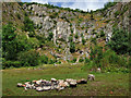
Dyserth Quarry - site of Dyserth Castle
Coflein place the site of the C13 stone castle slap bang in the middle of the quarry (at Image) which is at odds with the location over 300 metres further east inaccurately indicated on modern Explorer Ordnance Survey maps. To be fair, the modern 1:50,000 OS map has it marked far more accurately, although one has to refer to a map of 1913 in order to discover the true site of the castle. At that time a few ruined towers and curtain walls were still standing, and these are marked correctly on the 1913 map. Subsequently most of the stone castle was destroyed by quarrying here in the early C20 leaving on the escarpment above, only the earthworks of the outer court and part of the ditch.
Youtube video: https://www.youtube.com/watch?v=0VFs9CLaOPQ
Image: © Mike Searle
Taken: 19 Jun 2019
0.12 miles
6
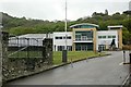
The Falls are fallen
The Falls Resort, which included a hotel and timeshare chalets, closed in 2015 and finally went into liquidation in early 2019.
Image: © Alan Murray-Rust
Taken: 9 May 2019
0.13 miles
7
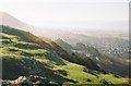
Graig Fawr view
The view from the top of Graig Fawr, looking southwest.
Image: © Chris Downer
Taken: 16 Feb 2004
0.14 miles
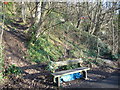
8
Ruin near the Graig Park Hotel.
Large ruin, possibly from an old mine, south of Meliden.
Image: © Eirian Evans
Taken: 29 Jan 2008
0.15 miles
9
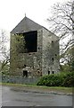
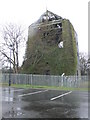
Clive Shaft engine house, Talargoch mine, Dyserth ? 1
Taken – purely by chance - from almost the exact location as http://www.geograph.org.uk/photo/671382 which shows the building before restoration. See http://www.geograph.org.uk/photo/6150722 for more information.
Image: © Alan Murray-Rust
Taken: 9 May 2019
0.15 miles
10
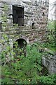
Clive Shaft engine house, Talargoch mine, Dyserth ? 6
The north side of the engine house showing the top of the pump shaft. This was D-shaped with a platform next to the engine house where the condenser for the engine was located; the pipes to the condeser came out through the lower arch. See http://www.geograph.org.uk/photo/6150722 for more information.
Image: © Alan Murray-Rust
Taken: 9 May 2019
0.15 miles