IMAGES TAKEN NEAR TO
Elm Grove, RHYL, LL18 3PE
Introduction
This page details the photographs taken nearby to Elm Grove, LL18 3PE by members of the Geograph project.
The Geograph project started in 2005 with the aim of publishing, organising and preserving representative images for every square kilometre of Great Britain, Ireland and the Isle of Man.

There are currently over 7.5m images from over14,400 individuals and you can help contribute to the project by visiting https://www.geograph.org.uk
Image Map
Images are licensed for reuse under creativecommons.org/licenses/by-sa/2.0
Notes
- Clicking on the map will re-center to the selected point.
- The higher the marker number, the further away the image location is from the centre of the postcode.
Image Listing (32 Images Found)
Images are licensed for reuse under creativecommons.org/licenses/by-sa/2.0
Image
Details
Distance
1
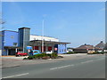
Rhyl Community Fire Station
On Rhyl Coast Road.
Image: © Eirian Evans
Taken: 2 May 2012
0.10 miles
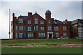
2
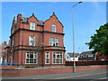
Edith Vizard Memorial Home, Russell Road
Edith Maria Vizard was the Honorary Superintendent of the Royal Alexandra hospital for 35 years, until her death in April 1908. The hospital was originally a hospital for sick children. Miss Vizard and a Miss Graham took charge of the hospital in the early 1870’s. Miss Vizard was Matron, or “Lady Superintendent” as the job was called then, at Great Ormond Street Hospital for two years before leaving to take up her post here in Rhyl. She took no remuneration for this. After her death, there was a call for a permanent memorial to Miss Vizard. The hospital committee decided that it would be particularly appropriate to connect such a memorial with the provision of a separate house for the large staff of nurses. It was therefore decided to purchase this building, “Hendre”, which had been rented by the committee for the temporary accommodation of convalescent patients. The committee secured the house for £1,500, which was paid for by subscription. http://historypoints.org/index.php?page=edith-vizard-memorial-home
Image: © Eirian Evans
Taken: 2 May 2012
0.13 miles
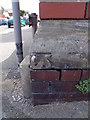
3
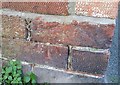
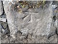
Ordnance Survey Cut Mark
This OS cut mark can be found on the wall of No25 Highfield Park. It marks a point 7.795m above mean sea level.
Image: © Adrian Dust
Taken: 13 Sep 2019
0.14 miles
4
Benchmark on Old Golf Road, Rhyl
This benchmark is located on the SW side of Old Golf Road in Rhyl & it is shown in the current Ordnance Survey database at a height of 7.6413m above the Newlyn datum.
Image: © Meirion
Taken: 28 Jun 2011
0.16 miles
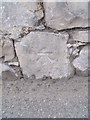
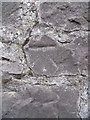
5
Ordnance Survey Cut Mark
This OS cut mark can be found on the wall SW side of Old Golf Road. It marks a point 7.641m above mean sea level.
Image: © Adrian Dust
Taken: 13 Sep 2019
0.16 miles
6
Benchmark on Russell Road, Rhyl
This benchmark is located on the SE side of Russell Road in Rhyl and it is shown in the current Ordnance Survey database at a height of 11.2441m above the Newlyn datum.
Image: © Meirion
Taken: 14 Oct 2011
0.18 miles
7
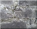
Ordnance Survey Cut Mark
This OS cut mark can be found on the wall SE side of Russell Road. It marks a point 8.281m above mean sea level.
Image: © Adrian Dust
Taken: 13 Sep 2019
0.18 miles
9
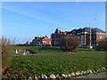
Marine Drive, Rhyl
Facing the sea and the Gorsedd Stones.
Image: © Eirian Evans
Taken: 7 Jan 2012
0.19 miles
10
Benchmark at the junction of Marine Drive & Grosvenor Road, Rhyl
This benchmark is located at the wall junction of Marine Drive & Grosvenor Road (hospital boundary wall) in Rhyl & it is shown in the current Ordnance Survey database at a height of 9.7803mm above the Newlyn datum.
Image: © Meirion
Taken: 28 Jun 2011
0.19 miles