IMAGES TAKEN NEAR TO
Paradise Street, RHYL, LL18 3LW
Introduction
This page details the photographs taken nearby to Paradise Street, LL18 3LW by members of the Geograph project.
The Geograph project started in 2005 with the aim of publishing, organising and preserving representative images for every square kilometre of Great Britain, Ireland and the Isle of Man.

There are currently over 7.5m images from over14,400 individuals and you can help contribute to the project by visiting https://www.geograph.org.uk
Image Map
Images are licensed for reuse under creativecommons.org/licenses/by-sa/2.0
Notes
- Clicking on the map will re-center to the selected point.
- The higher the marker number, the further away the image location is from the centre of the postcode.
Image Listing (195 Images Found)
Images are licensed for reuse under creativecommons.org/licenses/by-sa/2.0
Image
Details
Distance
1
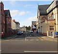
Paradise Street, Rhyl
Viewed across Brighton Road. Paradise Street is Heol Gwynfa in Welsh.
Image: © Jaggery
Taken: 1 Nov 2017
0.01 miles
2
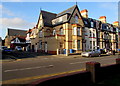
Corner of Brighton Road and Paradise Street, Rhyl
The A548 Brighton Road is on the right side of the corner.
Image: © Jaggery
Taken: 1 Nov 2017
0.02 miles
3

Ordnance Survey Cut Mark
This OS cut mark can be found on the wall at the junction of Paradise Street & Brighton Road. It marks a point 6.776m above mean sea level.
Image: © Adrian Dust
Taken: 13 Sep 2019
0.02 miles
4

Directions sign on a Rhyl corner
On the corner of Brighton Road and Thorpe Street.
Image: © Jaggery
Taken: 1 Nov 2017
0.03 miles
5

Mandatory left turn, Thorpe Street, Rhyl
At the A548 Brighton Road junction.
Image: © Jaggery
Taken: 1 Nov 2017
0.03 miles
6
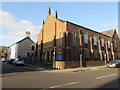
Eglwys Bresbyteraidd Cymru, Rhyl
The Clwyd Street/Brighton Road corner of the church (Welsh Presbyterian Church in English).
The Grade II listed building dates from 1855.
Image: © Jaggery
Taken: 1 Nov 2017
0.04 miles
7
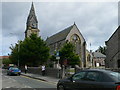
St Thomas Church, Rhyl
The foundation stone of St. Thomas's church was laid on Whit Monday, 20 May 1861 and the church was opened for worship in 1862.
Image: © Eirian Evans
Taken: 14 Sep 2007
0.04 miles
8
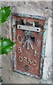
Ordnance Survey Flush Bracket (S0350)
This OS Flush Bracket can be found on the NW face of Holy Trinity Church. It marks a point 7.339m above mean sea level.
Image: © Adrian Dust
Taken: 13 Sep 2019
0.04 miles
9
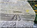
Ordnance Survey Cut Mark
This OS cut mark can be found on the Porch of St Thomas Church. It marks a point 7.262m above mean sea level.
Image: © Adrian Dust
Taken: 13 Sep 2019
0.04 miles