
IMAGES TAKEN NEAR TO
Diane Drive, RHYL, LL18 2NG
Introduction
This page details the photographs taken nearby to Diane Drive, LL18 2NG by members of the Geograph project.
The Geograph project started in 2005 with the aim of publishing, organising and preserving representative images for every square kilometre of Great Britain, Ireland and the Isle of Man.

There are currently over 7.5m images from over14,400 individuals and you can help contribute to the project by visiting https://www.geograph.org.uk
Image Map
Images are licensed for reuse under creativecommons.org/licenses/by-sa/2.0
Notes
- Clicking on the map will re-center to the selected point.
- The higher the marker number, the further away the image location is from the centre of the postcode.
Image Listing (5 Images Found)
Images are licensed for reuse under creativecommons.org/licenses/by-sa/2.0
Image
Details
Distance
1
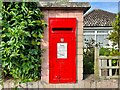
Post Box at Rhyl
LL18 110. Royal Mail list this box as 'Viola Avenue'.
Image: © David Bremner
Taken: 15 Jun 2022
0.14 miles
2
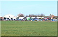
Ysgol Tir Morfa
Rhyl school for children with special needs.
Image: © Eirian Evans
Taken: 27 Feb 2008
0.23 miles
3
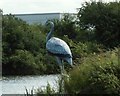
Old Brickworks Pond, Rhyl
"Grey Heron standing motionless in shallow water"
....... A long standing feature of the waterpark
Image: © IB
Taken: 6 Jul 2005
0.23 miles
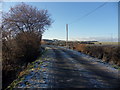
5
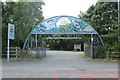
Entrance to Brickfield Pond
A nature reserve created on a former clay pit.
Image: © Richard Hoare
Taken: 8 Sep 2019
0.25 miles