IMAGES TAKEN NEAR TO
Gwynfryn Avenue, RHYL, LL18 2BD
Introduction
This page details the photographs taken nearby to Gwynfryn Avenue, LL18 2BD by members of the Geograph project.
The Geograph project started in 2005 with the aim of publishing, organising and preserving representative images for every square kilometre of Great Britain, Ireland and the Isle of Man.

There are currently over 7.5m images from over14,400 individuals and you can help contribute to the project by visiting https://www.geograph.org.uk
Image Map
Images are licensed for reuse under creativecommons.org/licenses/by-sa/2.0
Notes
- Clicking on the map will re-center to the selected point.
- The higher the marker number, the further away the image location is from the centre of the postcode.
Image Listing (19 Images Found)
Images are licensed for reuse under creativecommons.org/licenses/by-sa/2.0
Image
Details
Distance
1
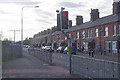
Ffordd Las, Rhyl
1930s style semi-detached houses line the eastern side of Ffordd Las leading away from its junction with Marsh Road.
Image: © Stephen McKay
Taken: 8 Oct 2021
0.15 miles
2
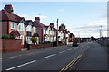
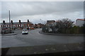
Marsh Road, Rhyl
Much of Rhyl has the air of a northern English town dropped onto the Welsh coast - nowhere more so than here where a line of brick-built terraced houses overlooks a playing field.
Image: © Stephen McKay
Taken: 8 Oct 2021
0.19 miles
3
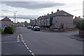
Kingsley Avenue, Rhyl
Local authority built housing in the suburbs of Rhyl.
Image: © Stephen McKay
Taken: 8 Oct 2021
0.19 miles
4
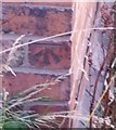
Ordnance Survey Cut Mark
This OS cut mark can be found on No73 Marsh Road. It marks a point 4.751m above mean sea level.
Image: © Adrian Dust
Taken: 13 Sep 2019
0.19 miles
6
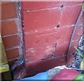
Ordnance Survey Cut Mark
This OS cut mark can be found on No58 Marsh Road. It marks a point 4.714m above mean sea level.
Image: © Adrian Dust
Taken: 13 Sep 2019
0.22 miles
7
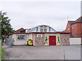
Pied Piper Child Care Centre
This used to be a Chapel belonging to the Presbyterian Church in Wales.
Image: © David and Rachel Landin
Taken: 16 Jun 2007
0.22 miles
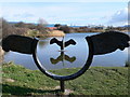
8
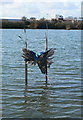
Kingfisher, Brickfields Pond
One of many sculptures around this former claypit.
Image: © Eirian Evans
Taken: 27 Feb 2008
0.22 miles
9
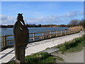
Brickfields Pond, Rhyl
Once a claypit, this has now been developed into a Local Nature Reserve which is now a haven for birds and wildfowl.
Image: © Eirian Evans
Taken: 27 Feb 2008
0.22 miles
10
Cormorant sculpture, Brickfields Pond
Brickfields Pond was initially a flooded clay pit which had become derelict and a haven for fly tipping. It was the first site in North East Wales to be designated a Local Nature Reserve and is now a haven for birds and wildfowl. There are several sculptures around the park of which this is one.
Image: © Eirian Evans
Taken: 27 Feb 2008
0.22 miles