IMAGES TAKEN NEAR TO
Marsh Road, RHYL, LL18 2AE
Introduction
This page details the photographs taken nearby to Marsh Road, LL18 2AE by members of the Geograph project.
The Geograph project started in 2005 with the aim of publishing, organising and preserving representative images for every square kilometre of Great Britain, Ireland and the Isle of Man.

There are currently over 7.5m images from over14,400 individuals and you can help contribute to the project by visiting https://www.geograph.org.uk
Image Map
Images are licensed for reuse under creativecommons.org/licenses/by-sa/2.0
Notes
- Clicking on the map will re-center to the selected point.
- The higher the marker number, the further away the image location is from the centre of the postcode.
Image Listing (92 Images Found)
Images are licensed for reuse under creativecommons.org/licenses/by-sa/2.0
Image
Details
Distance
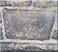
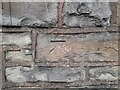
1
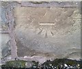
Ordnance Survey Cut Mark
This OS cut mark can be found on the wall SE side of the road. It marks a point 10.016m above mean sea level.
Image: © Adrian Dust
Taken: 13 Sep 2019
0.05 miles
2
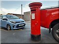
Postbox at Rhyl
LL18 161. Royal Mail list this box as 'Marsh Road'.
Image: © David Bremner
Taken: 6 Nov 2022
0.05 miles
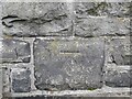
3
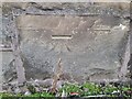
OS Benchmark
Recorded on Benchmark Database as 'Rhyl, Marsh Road'.
Image: © David Bremner
Taken: 6 Nov 2022
0.05 miles
4
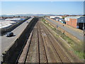
The Chester to Holyhead railway line at Rhyl
Image: © Nigel Thompson
Taken: 18 Apr 2015
0.05 miles
5
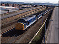
Trains at Rhyl - 1993 (5)
Diesel locomotive 37429 approaches Rhyl station with the 16.00 passenger service from Holyhead to Stafford.
Image: © The Carlisle Kid
Taken: 23 Jun 1993
0.06 miles
6
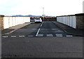
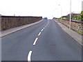
Road bridge over the North Wales Coast Line railway, Rhyl
Viewed from the unnamed road between Ffynnongroew Road and Warren Road. Ahead for Marsh Road.
Image: © Jaggery
Taken: 1 Nov 2017
0.06 miles
7
Ordnance Survey Cut Mark
This OS cut mark can be found on the wall SE side of the road. It marks a point 6.133m above mean sea level.
Image: © Adrian Dust
Taken: 13 Sep 2019
0.06 miles
8
OS Benchmark
Recorded on Benchmark Database as 'Rhyl, H Bridge'.
Image: © David Bremner
Taken: 6 Nov 2022
0.06 miles
9
The H Bridge in Rhyl
A railway bridge built in an H shape with four approach roads (parallel to the railway tracks) and one crossing span.
Image: © David and Rachel Landin
Taken: 30 Jul 2005
0.06 miles
10
OS Benchmark
Recorded on Benchmark Database as 'Rhyl, H Bridge'.
Image: © David Bremner
Taken: 6 Nov 2022
0.07 miles