
IMAGES TAKEN NEAR TO
Orton Grove, RHYL, LL18 1DG
Introduction
This page details the photographs taken nearby to Orton Grove, LL18 1DG by members of the Geograph project.
The Geograph project started in 2005 with the aim of publishing, organising and preserving representative images for every square kilometre of Great Britain, Ireland and the Isle of Man.

There are currently over 7.5m images from over14,400 individuals and you can help contribute to the project by visiting https://www.geograph.org.uk
Image Map
Images are licensed for reuse under creativecommons.org/licenses/by-sa/2.0
Notes
- Clicking on the map will re-center to the selected point.
- The higher the marker number, the further away the image location is from the centre of the postcode.
Image Listing (114 Images Found)
Images are licensed for reuse under creativecommons.org/licenses/by-sa/2.0
Image
Details
Distance
1
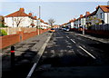
Ellis Avenue, Rhyl
From the corner of Warren Road along Ellis Avenue towards Barry Road and Garnett Avenue.
Image: © Jaggery
Taken: 1 Nov 2017
0.04 miles
2
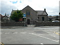
Holy Trinity & St John The Baptist Church, Rhyl
Holy Trinity church was initially a chapel of ease to the parish church of Rhuddlan. It was consecrated on 19 May 1836.
Rhyl became a separate parish on the 23rd May 1844, and Holy Trinity became the parish church.
Image: © Eirian Evans
Taken: 14 Sep 2007
0.06 miles
3
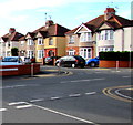
Terence Avenue semis, Rhyl
Semi-detached houses in Terence Avenue viewed across Ffynnongroew Road from West Kinmel Street.
Image: © Jaggery
Taken: 1 Nov 2017
0.07 miles
4
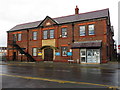
Rhyl Territorial Drill Hall 1914
The Territorial Drill Hall is on the corner of John Street and Crescent Road. It was built in 1914, at the outbreak of World War 1, as the drill station for the 5th Battalion, Royal Welch Fusiliers (C Company) and Denbighshire Hussars (B Squadron). See also Image
Image: © John S Turner
Taken: 1 Nov 2013
0.10 miles
5
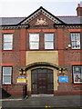
Rhyl Territorial Drill Hall entrance
The Territorial Drill Hall was built in 1914, at the outbreak of World War 1, as the drill station for the 5th Battalion, Royal Welch Fusiliers (C Company) and Denbighshire Hussars (B Squadron). The fine stone plaque above the entrance makes its purpose quite clear. The modern signs either side of the door are for the Army Cadets - www.armycadets.com and the Royal Air Force Air Cadets 1340 Squadron Rhyl - www.rhylaircadets.co.uk
For a photo of the main building see also: Image
Image: © John S Turner
Taken: 1 Nov 2013
0.10 miles
6

Arriva Bus Depot, Rhyl
Recently-built depot and bus garage viewed in November 2017.
Image: © Jaggery
Taken: 1 Nov 2017
0.10 miles
7
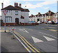
Speed bump at the SW end of West Kinmel Street, Rhyl
On the approach to the Ffynnongroew Road junction.
Image: © Jaggery
Taken: 1 Nov 2017
0.10 miles
8
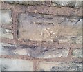
Ordnance Survey Cut Mark
This OS cut mark can be found on the wall NW side of the road. It marks a point 8.071m above mean sea level.
Image: © Adrian Dust
Taken: 13 Sep 2019
0.10 miles
9
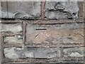
OS Benchmark
Recorded on Benchmark Database as 'Rhyl, H Bridge'.
Image: © David Bremner
Taken: 6 Nov 2022
0.10 miles
10

Road above Arriva Bus Depot, Rhyl
This apparently unnamed road is between Ffynnongroew Road and Warren Road (out of shot ahead).
Arriva's Bus Depot https://www.geograph.org.uk/photo/5939106 is below the wall on the right.
Image: © Jaggery
Taken: 1 Nov 2017
0.10 miles