IMAGES TAKEN NEAR TO
Wellington Road, RHYL, LL18 1AB
Introduction
This page details the photographs taken nearby to Wellington Road, LL18 1AB by members of the Geograph project.
The Geograph project started in 2005 with the aim of publishing, organising and preserving representative images for every square kilometre of Great Britain, Ireland and the Isle of Man.

There are currently over 7.5m images from over14,400 individuals and you can help contribute to the project by visiting https://www.geograph.org.uk
Image Map
Images are licensed for reuse under creativecommons.org/licenses/by-sa/2.0
Notes
- Clicking on the map will re-center to the selected point.
- The higher the marker number, the further away the image location is from the centre of the postcode.
Image Listing (269 Images Found)
Images are licensed for reuse under creativecommons.org/licenses/by-sa/2.0
Image
Details
Distance
1
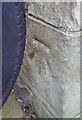
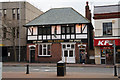
Ordnance Survey Cut Mark
This OS cut mark can be found on the north angle of the Town Hall. It marks a point 6.394m above mean sea level.
Image: © Adrian Dust
Taken: 13 Sep 2019
0.01 miles
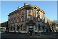
2
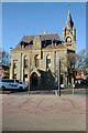
Rhyl Town Hall
Rhyl town hall was built in 1874-6, to designs of Wood and Turner of Barrow. The clock tower has a distinct lean.
Image: © Philip Halling
Taken: 26 May 2021
0.01 miles
3
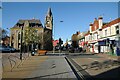
Wellington Street
Wellington Street and Rhyl Town Hall. Rhyl town hall was built in 1874-6, to designs of Wood and Turner of Barrow. The clock tower has a distinct lean.
Image: © Philip Halling
Taken: 26 May 2021
0.01 miles
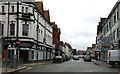
6
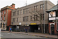
HSBC Bank
HSBC Bank on the corner of Wellington Street and Bodfor Street in Rhyl.
Image: © Philip Halling
Taken: 26 May 2021
0.03 miles
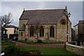
10
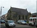
Christ Church, Rhyl
Opened in 1858 as an English congregation, the church on Water Street deteriorated so much within 30 years that it was declared unsafe and was demolished. A new building was erected on the same site in 1885. It is now a member of the United Reformed Church.
Image: © Eirian Evans
Taken: 11 Jan 2008
0.04 miles