IMAGES TAKEN NEAR TO
Rhuallt, ST. ASAPH, LL17 0TP
Introduction
This page details the photographs taken nearby to LL17 0TP by members of the Geograph project.
The Geograph project started in 2005 with the aim of publishing, organising and preserving representative images for every square kilometre of Great Britain, Ireland and the Isle of Man.

There are currently over 7.5m images from over14,400 individuals and you can help contribute to the project by visiting https://www.geograph.org.uk
Image Map (Loading...)


Getting Data...Please wait
Leaflet Map data © OpenStreetMap
Images are licensed for reuse under creativecommons.org/licenses/by-sa/2.0
Notes
- Clicking on the map will re-center to the selected point.
- The higher the marker number, the further away the image location is from the centre of the postcode.
Image Listing (15 Images Found)
Images are licensed for reuse under creativecommons.org/licenses/by-sa/2.0
Image
Details
Distance
1

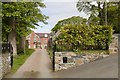
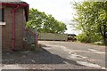
Brynllithrig Hall
A collection of old buildings above Rhuallt.
Image: © John Allan
Taken: 30 Jun 2019
0.02 miles
3
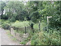
Offa's Dyke Path near Brynllithrig Hall, Rhuallt
The start of a steep climb up Mynydd y Cwm if you're heading north along the path.
Image: © Eirian Evans
Taken: 22 Jul 2020
0.07 miles
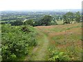
4
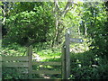
Offa's Dyke Path by Brynllithrig Hall
The trail leaves the lane from Rhuallt to climb steeply through woodland on the slopes of Mynydd y Cwm.
Image: © Chris Heaton
Taken: 12 May 2009
0.07 miles
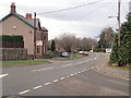
5
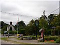
Rhuallt village centre
The crossroads at the centre of the village of Rhuallt
Image: © Dot Potter
Taken: 22 Jul 2005
0.16 miles
6
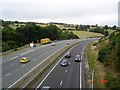
Rhuallt hill A55
Traffic on Rhuallt hill on the A55 taken from the footbridge which crosses at Rhuallt
Image: © Dot Potter
Taken: 22 Jul 2005
0.16 miles
7
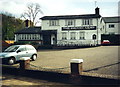
The Smithy Arms
Tafarn y Smithy Arms, Rhuallt, yn 2000.
The Smithy Arms, Rhuallt (trans. extreme hill) in 2000.
Image: © Alan Richards
Taken: 24 Apr 2000
0.21 miles
9
Offa's Dyke Path descending to Rhuallt
150m of descent, a steep hillside.
Image: © Eirian Evans
Taken: 22 Jul 2020
0.22 miles
10
Steps and playground Rhuallt village school
There is a cut bench mark on the third step. Bench Mark Database: https://www.bench-marks.org.uk/bm107744
Image: © Mark Anderson
Taken: 6 May 2019
0.23 miles