IMAGES TAKEN NEAR TO
Mill Street, ST. ASAPH, LL17 0SP
Introduction
This page details the photographs taken nearby to Mill Street, LL17 0SP by members of the Geograph project.
The Geograph project started in 2005 with the aim of publishing, organising and preserving representative images for every square kilometre of Great Britain, Ireland and the Isle of Man.

There are currently over 7.5m images from over14,400 individuals and you can help contribute to the project by visiting https://www.geograph.org.uk
Image Map (Loading...)


Getting Data...Please wait
Leaflet Map data © OpenStreetMap
Images are licensed for reuse under creativecommons.org/licenses/by-sa/2.0
Notes
- Clicking on the map will re-center to the selected point.
- The higher the marker number, the further away the image location is from the centre of the postcode.
Image Listing (68 Images Found)
Images are licensed for reuse under creativecommons.org/licenses/by-sa/2.0
Image
Details
Distance
1
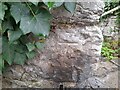
Ordnance Survey Cut Mark
This OS cut mark can be found on the wall next to the steps on Red Hill. It marks a point 23.622m above mean sea level.
Image: © Adrian Dust
Taken: 28 Mar 2023
0.04 miles
3
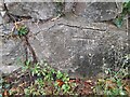
Ordnance Survey Cut Mark
This OS cut mark can be found on the wall NW side of Red Hill. It marks a point 34.016m above mean sea level.
Image: © Adrian Dust
Taken: 28 Mar 2023
0.06 miles
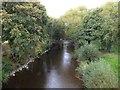
4
Pont Begard, St Asaph
The bridge, named Pont Begard after St. Asaph's twin town, is designed to connect east and west St. Asaph. It's strong enough and wide enough to take a vehicle in an emergency.
Image: © Eirian Evans
Taken: 20 Apr 2012
0.07 miles
5
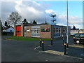
Fire Station, St Asaph
The fire station was moved here (The Roe) in 1971 from its former site on Upper Denbigh Road. It is next to the town library.
Image: © Eirian Evans
Taken: 9 Nov 2007
0.07 miles
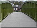
6
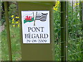
Pont Begard
Sign on the bridge, named Pont Begard after St. Asaph's twin town, designed to connect east and west St. Asaph.
Image: © Eirian Evans
Taken: 20 Apr 2012
0.08 miles
7
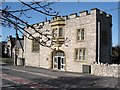
The Dean's library
Opposite St.Asaph Cathedral the Dean's Library
Image: © Dot Potter
Taken: 16 Apr 2006
0.09 miles
8
Bryn Dinas
The Bryn Dinas public house opposite St.Asaph cathedral in the centre of the 'city'.
Image: © Dot Potter
Taken: 16 Apr 2006
0.09 miles
9
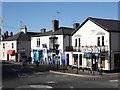
Village 'city' centre
St.Asaph city centre on a Sunday afternoon. The 'city' gains its status from the nearby cathedral, however its more of a village in terms of size.
Image: © Dot Potter
Taken: 16 Apr 2006
0.09 miles
10
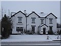
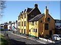
Plas Elwy
Hotel and restaurant in the city of St. Asaph
Image: © Dot Potter
Taken: 12 Mar 2006
0.09 miles