IMAGES TAKEN NEAR TO
Bryn Elwy, ST. ASAPH, LL17 0RU
Introduction
This page details the photographs taken nearby to Bryn Elwy, LL17 0RU by members of the Geograph project.
The Geograph project started in 2005 with the aim of publishing, organising and preserving representative images for every square kilometre of Great Britain, Ireland and the Isle of Man.

There are currently over 7.5m images from over14,400 individuals and you can help contribute to the project by visiting https://www.geograph.org.uk
Image Map (Loading...)


Getting Data...Please wait
Leaflet Map data © OpenStreetMap
Images are licensed for reuse under creativecommons.org/licenses/by-sa/2.0
Notes
- Clicking on the map will re-center to the selected point.
- The higher the marker number, the further away the image location is from the centre of the postcode.
Image Listing (9 Images Found)
Images are licensed for reuse under creativecommons.org/licenses/by-sa/2.0
Image
Details
Distance
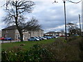
1
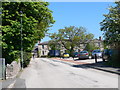
H M Stanley Hospital, St Asaph
Community hospital in St Asaph
Image: © Eirian Evans
Taken: 28 Apr 2011
0.04 miles
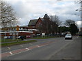
4
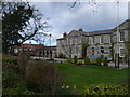
H M Stanley Hospital
Originally the St Asaph Union Workhouse, where Henry Morton Stanley spent most of his childhood.
Image: © Eirian Evans
Taken: 27 Feb 2008
0.09 miles
5
H M Stanley Hospital, St Asaph
Formerly the St Asaph Union Workhouse, erected in 1838. http://www.workhouses.org.uk/index.html?StAsaph/StAsaph.shtml After 1930, the workhouse became St Asaph Public Assistance Institution. From 1910 until 1948, the St Asaph Infectious Diseases Hospital also operated on the site.
Image: © Eirian Evans
Taken: 27 Feb 2008
0.09 miles
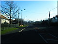
7
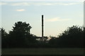
Incinerator Chimney - H.M. Stanley Hospital
Taken from the Clwydian Way National Trail.
Image: © Joseph Jones
Taken: 2 Jul 2010
0.17 miles
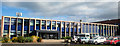
8
Ysgol Glan Clwyd, Llanelwy
Ysgol Glan Clwyd was Wales' first Welsh language secondary school. It opened in 1957 in Rhyl before moving to its present location in St Asaph.
Image: © Eirian Evans
Taken: 27 Feb 2008
0.19 miles
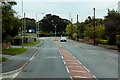
9
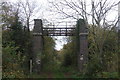
Old Railway Footbridge - St. Asaph
This derelict footbridge was on the old Rhyl to Denbigh Railway line. It was demolished sometime in 2010.
Note the "Clwydian Way Trail" waymark on the left. This footpath leads to a bridge over the River Clwyd then onto The Waen.
Image: © Joseph Jones
Taken: 23 Oct 2009
0.20 miles