IMAGES TAKEN NEAR TO
Bro Havard, ST. ASAPH, LL17 0NT
Introduction
This page details the photographs taken nearby to Bro Havard, LL17 0NT by members of the Geograph project.
The Geograph project started in 2005 with the aim of publishing, organising and preserving representative images for every square kilometre of Great Britain, Ireland and the Isle of Man.

There are currently over 7.5m images from over14,400 individuals and you can help contribute to the project by visiting https://www.geograph.org.uk
Image Map (Loading...)


Getting Data...Please wait
Leaflet Map data © OpenStreetMap
Images are licensed for reuse under creativecommons.org/licenses/by-sa/2.0
Notes
- Clicking on the map will re-center to the selected point.
- The higher the marker number, the further away the image location is from the centre of the postcode.
Image Listing (23 Images Found)
Images are licensed for reuse under creativecommons.org/licenses/by-sa/2.0
Image
Details
Distance
1
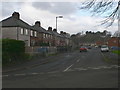
Heol Esgob near St Asaph
Looking south-westward.
Image: © Peter Wood
Taken: 21 Nov 2018
0.13 miles
2
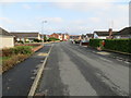
Heol Esgob in St Asaph
Looking north-eastward.
Image: © Peter Wood
Taken: 21 Nov 2018
0.15 miles
3
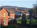
Llanelwy o'r de orllewin / St Asaph from the south west
Image: © Ceri Thomas
Taken: 26 Nov 2009
0.16 miles
4
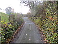
North Wales Pilgrims Way
The North Wales Pilgrims Way makes use of this minor road from St Asaph.
Image: © David Bremner
Taken: 9 Jun 2024
0.18 miles
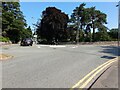
5
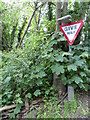
Give Way
At the junction of a minor road with the B5381.
Image: © David Bremner
Taken: 9 Jun 2024
0.18 miles
8
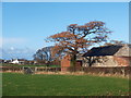
Ysgubor dan gysgod derwen / A barn under the shadow of an oak
Image: © Ceri Thomas
Taken: 26 Nov 2009
0.20 miles
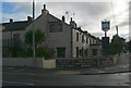
10
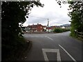
Mini-roundabout, St Asaph
This roundabout links the A525/ B5381 and St Asaph Bridge.
Image: © David Bremner
Taken: 20 Jul 2021
0.20 miles