IMAGES TAKEN NEAR TO
Erw Lan, ST. ASAPH, LL17 0LZ
Introduction
This page details the photographs taken nearby to Erw Lan, LL17 0LZ by members of the Geograph project.
The Geograph project started in 2005 with the aim of publishing, organising and preserving representative images for every square kilometre of Great Britain, Ireland and the Isle of Man.

There are currently over 7.5m images from over14,400 individuals and you can help contribute to the project by visiting https://www.geograph.org.uk
Image Map (Loading...)


Getting Data...Please wait
Leaflet Map data © OpenStreetMap
Images are licensed for reuse under creativecommons.org/licenses/by-sa/2.0
Notes
- Clicking on the map will re-center to the selected point.
- The higher the marker number, the further away the image location is from the centre of the postcode.
Image Listing (25 Images Found)
Images are licensed for reuse under creativecommons.org/licenses/by-sa/2.0
Image
Details
Distance
3
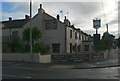
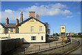
Footpath at rear of Tan-y-bryn, St Asaph
Image: © Gary Rogers
Taken: 16 Oct 2016
0.13 miles
4
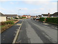
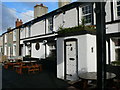
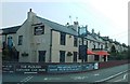
Heol Esgob in St Asaph
Looking north-eastward.
Image: © Peter Wood
Taken: 21 Nov 2018
0.15 miles
6
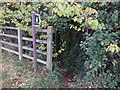
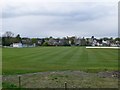
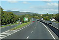
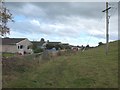
Footpath from the A55 to Heol Esgob
On the western outskirts of St Asaph
Image: © Gary Rogers
Taken: 16 Oct 2016
0.16 miles