IMAGES TAKEN NEAR TO
Glascoed Road, ST. ASAPH, LL17 0LL
Introduction
This page details the photographs taken nearby to Glascoed Road, LL17 0LL by members of the Geograph project.
The Geograph project started in 2005 with the aim of publishing, organising and preserving representative images for every square kilometre of Great Britain, Ireland and the Isle of Man.

There are currently over 7.5m images from over14,400 individuals and you can help contribute to the project by visiting https://www.geograph.org.uk
Image Map (Loading...)


Getting Data...Please wait
Leaflet Map data © OpenStreetMap
Images are licensed for reuse under creativecommons.org/licenses/by-sa/2.0
Notes
- Clicking on the map will re-center to the selected point.
- The higher the marker number, the further away the image location is from the centre of the postcode.
Image Listing (3 Images Found)
Images are licensed for reuse under creativecommons.org/licenses/by-sa/2.0
Image
Details
Distance
1
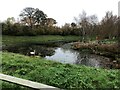
Pond with a lonely swan
Near the St Asaph business park
Image: © Eirian Evans
Taken: 23 Nov 2021
0.09 miles
2
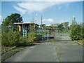
The Factory Gates Are Closed
The entrance to the former Pilkington Special Glass works, demolished in 2009.
Image: © Chris Andrews
Taken: 15 Sep 2021
0.13 miles
3
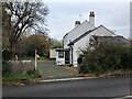
Carreg Wen Cottage
Near the roundabout at St Asaph Business Park
Image: © Eirian Evans
Taken: 23 Nov 2021
0.20 miles