IMAGES TAKEN NEAR TO
Hen Waliau, ST. ASAPH, LL17 0HX
Introduction
This page details the photographs taken nearby to Hen Waliau, LL17 0HX by members of the Geograph project.
The Geograph project started in 2005 with the aim of publishing, organising and preserving representative images for every square kilometre of Great Britain, Ireland and the Isle of Man.

There are currently over 7.5m images from over14,400 individuals and you can help contribute to the project by visiting https://www.geograph.org.uk
Image Map (Loading...)


Getting Data...Please wait
Leaflet Map data © OpenStreetMap
Images are licensed for reuse under creativecommons.org/licenses/by-sa/2.0
Notes
- Clicking on the map will re-center to the selected point.
- The higher the marker number, the further away the image location is from the centre of the postcode.
Image Listing (10 Images Found)
Images are licensed for reuse under creativecommons.org/licenses/by-sa/2.0
Image
Details
Distance
4
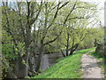
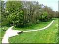
Footpath beside the river Elwy, approaching St Asaph
Image: © Eirian Evans
Taken: 20 Apr 2012
0.17 miles
5
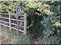
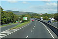
Footpath from the A55 to Heol Esgob
On the western outskirts of St Asaph
Image: © Gary Rogers
Taken: 16 Oct 2016
0.18 miles
6
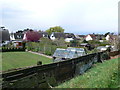
Back gardens in St Asaph
Seen from the path which follows the river Elwy
Image: © Eirian Evans
Taken: 20 Apr 2012
0.18 miles
7
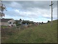
Footpath at rear of Tan-y-bryn, St Asaph
Image: © Gary Rogers
Taken: 16 Oct 2016
0.21 miles
8

Spring has sprung!
Crab-apple blossom beside the river Elwy
Image: © Eirian Evans
Taken: 20 Apr 2012
0.21 miles
9
Bank of River Elwy in St Asaph
View from the road bridge looking northwards.
Image: © George Tod
Taken: 28 Apr 2007
0.24 miles
10
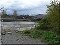
St Asaph Livestock Market
From the Elwy riverside path.
Image: © Eirian Evans
Taken: 20 Apr 2012
0.25 miles