IMAGES TAKEN NEAR TO
Maes Robert, ST. ASAPH, LL17 0HR
Introduction
This page details the photographs taken nearby to Maes Robert, LL17 0HR by members of the Geograph project.
The Geograph project started in 2005 with the aim of publishing, organising and preserving representative images for every square kilometre of Great Britain, Ireland and the Isle of Man.

There are currently over 7.5m images from over14,400 individuals and you can help contribute to the project by visiting https://www.geograph.org.uk
Image Map (Loading...)


Getting Data...Please wait
Leaflet Map data © OpenStreetMap
Images are licensed for reuse under creativecommons.org/licenses/by-sa/2.0
Notes
- Clicking on the map will re-center to the selected point.
- The higher the marker number, the further away the image location is from the centre of the postcode.
Image Listing (7 Images Found)
Images are licensed for reuse under creativecommons.org/licenses/by-sa/2.0
Image
Details
Distance
1
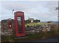
Blwch ffon ar oleddf / A lop-sided phone booth
Image: © Ceri Thomas
Taken: 28 Oct 2009
0.01 miles
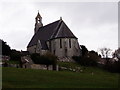
5
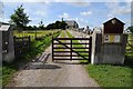
Gate and drive to St Mary's Church, Cefn Meriadog
Image: © Philip Halling
Taken: 14 Aug 2014
0.15 miles
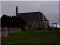
6
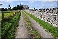
Drive to St Mary's Church, Cefn Meriadog
Image: © Philip Halling
Taken: 14 Aug 2014
0.15 miles
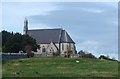
7
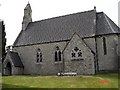
St Mary's Church, Cefn Pella
The parish church in Cefn Pella
Image: © Dot Potter
Taken: 9 Jul 2005
0.18 miles