IMAGES TAKEN NEAR TO
Cefn, ST. ASAPH, LL17 0EU
Introduction
This page details the photographs taken nearby to LL17 0EU by members of the Geograph project.
The Geograph project started in 2005 with the aim of publishing, organising and preserving representative images for every square kilometre of Great Britain, Ireland and the Isle of Man.

There are currently over 7.5m images from over14,400 individuals and you can help contribute to the project by visiting https://www.geograph.org.uk
Image Map
Images are licensed for reuse under creativecommons.org/licenses/by-sa/2.0
Notes
- Clicking on the map will re-center to the selected point.
- The higher the marker number, the further away the image location is from the centre of the postcode.
Image Listing (5 Images Found)
Images are licensed for reuse under creativecommons.org/licenses/by-sa/2.0
Image
Details
Distance
1
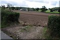
Arable field and Glascoed
Arable field with the woodland of Glascoed in the background.
Image: © Philip Halling
Taken: 14 Aug 2014
0.11 miles
2
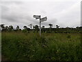
North Wales Pilgrims Way
Signpost with a North Wales Pilgrims Way marker on the post.
Image: © David Bremner
Taken: 9 Jun 2024
0.15 miles
3
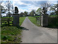
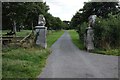
Gateway & drive to Plas-yn-Cefn
West of Trefnant
Image: © Eirian Evans
Taken: 29 Apr 2008
0.19 miles
4
Gateway to Plas-yn-cefn
Entrance and drive to Plas-yn-cefn.
Image: © Philip Halling
Taken: 14 Aug 2014
0.19 miles