IMAGES TAKEN NEAR TO
Rhodfa Glenys, ST. ASAPH, LL17 0DW
Introduction
This page details the photographs taken nearby to Rhodfa Glenys, LL17 0DW by members of the Geograph project.
The Geograph project started in 2005 with the aim of publishing, organising and preserving representative images for every square kilometre of Great Britain, Ireland and the Isle of Man.

There are currently over 7.5m images from over14,400 individuals and you can help contribute to the project by visiting https://www.geograph.org.uk
Image Map
Images are licensed for reuse under creativecommons.org/licenses/by-sa/2.0
Notes
- Clicking on the map will re-center to the selected point.
- The higher the marker number, the further away the image location is from the centre of the postcode.
Image Listing (95 Images Found)
Images are licensed for reuse under creativecommons.org/licenses/by-sa/2.0
Image
Details
Distance
1
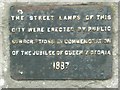
Sign on wall
This sign is on the wall around the cathedral, opposite the mini roundabout. (It can just be seen in Image)
Image: © David Luther Thomas
Taken: 17 Feb 2007
0.04 miles
3
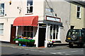
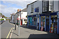
Shop near the cathedral
This has been a general grocery shop for at least 60 years.
Image: © John Howells Brown
Taken: 1 Jun 2008
0.08 miles
4
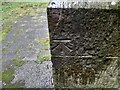
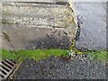
Ordnance Survey Cut Mark
This OS cut mark can be found on the east angle of the Mortuary Chapel. It marks a point 35.649m above mean sea level.
Image: © Adrian Dust
Taken: 28 Mar 2023
0.08 miles
5
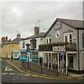
Mount Road, St Asaph
Seen from the junction with High Street, Mount Road runs north from the cathedral. On the right 'Simply Drinks' is an off-licence with, it would appear, a wide range of bargain offers.
Image: © Stephen McKay
Taken: 29 Aug 2009
0.14 miles
7
Mount Road, St Asaph
Mount Road is a no-through road that leads off the busy A525 junction in the centre of St Asaph.
Image: © Gerald England
Taken: 18 Mar 2019
0.14 miles
8
Ordnance Survey Cut Mark
This OS cut mark can be found on the building NW side of Chester Street. It marks a point 35.358m above mean sea level.
Image: © Adrian Dust
Taken: 28 Mar 2023
0.15 miles
9
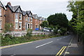
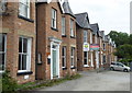
Houses on the A525
Houses on the A525 in St Asaph.
Image: © Philip Halling
Taken: 30 Aug 2013
0.15 miles
10
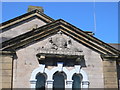
Royal coat of arms on the old Court House, St Asaph
Image: © Eirian Evans
Taken: 28 Apr 2011
0.15 miles