IMAGES TAKEN NEAR TO
Allt Goch, ST. ASAPH, LL17 0BW
Introduction
This page details the photographs taken nearby to Allt Goch, LL17 0BW by members of the Geograph project.
The Geograph project started in 2005 with the aim of publishing, organising and preserving representative images for every square kilometre of Great Britain, Ireland and the Isle of Man.

There are currently over 7.5m images from over14,400 individuals and you can help contribute to the project by visiting https://www.geograph.org.uk
Image Map
Images are licensed for reuse under creativecommons.org/licenses/by-sa/2.0
Notes
- Clicking on the map will re-center to the selected point.
- The higher the marker number, the further away the image location is from the centre of the postcode.
Image Listing (7 Images Found)
Images are licensed for reuse under creativecommons.org/licenses/by-sa/2.0
Image
Details
Distance
1
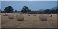
Harvest time in Trefnant
Clwydian Park opposite Nant Y Patrick
Image: © Thiru
Taken: 30 Sep 2011
0.10 miles
2
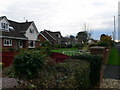
Trefnant houses
On the back road to Denbigh
Image: © Eirian Evans
Taken: 16 Nov 2007
0.11 miles
3
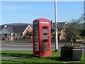
Blwch ffon traddodiadol / A traditional phone kiosk
Image: © Ceri Thomas
Taken: 27 Sep 2013
0.14 miles
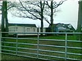
5
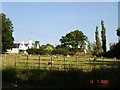
Trefnant fields
View over fields from road to village of Trefnant
Image: © Dot Potter
Taken: 12 Jul 2005
0.19 miles
6
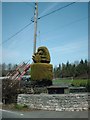
Green Raspberry
Topiary with Attitude
Image: © Ed Lloyd-Hughes
Taken: 8 Apr 2010
0.19 miles
7
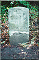
Old Milestone by the A525, St. Asaph Road, Trefnant
By the A525, in parish of Trefnant (Denbighshire District), Trefnant, St. Asaph Road North of Nant Padrig Bridge, South West side of road.
Inscription once read:-
(Denbigh
(III)
(Rhyddlan)
(V)
Grade II listed by Cadw. Reference Number: 19204
https://cadwpublic-api.azurewebsites.net/reports/listedbuilding/FullReport?lang=&id=19204
Surveyed
Milestone Society National ID: DEN_DBRL03
Image: © Milestone Society
Taken: Unknown
0.24 miles