IMAGES TAKEN NEAR TO
LL16 5YU
Introduction
This page details the photographs taken nearby to LL16 5YU by members of the Geograph project.
The Geograph project started in 2005 with the aim of publishing, organising and preserving representative images for every square kilometre of Great Britain, Ireland and the Isle of Man.

There are currently over 7.5m images from over14,400 individuals and you can help contribute to the project by visiting https://www.geograph.org.uk
Image Map
Images are licensed for reuse under creativecommons.org/licenses/by-sa/2.0
Notes
- Clicking on the map will re-center to the selected point.
- The higher the marker number, the further away the image location is from the centre of the postcode.
Image Listing (7 Images Found)
Images are licensed for reuse under creativecommons.org/licenses/by-sa/2.0
Image
Details
Distance
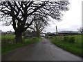
1
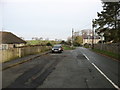
Leaving Groes on the B5428
Heading for Henllan.
Image: © David Purchase
Taken: 26 Dec 2018
0.09 miles
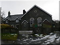
3
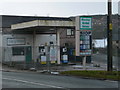
Menter Ardal Groes
Failed locally owned co-operative shop and garage at Groes, near Denbigh.
Image: © Eirian Evans
Taken: 11 Feb 2009
0.09 miles
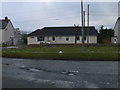
6
Approaching Groes from the Rhydgaled road
Image: © Eirian Evans
Taken: 12 Apr 2017
0.16 miles
7
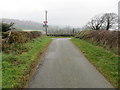
Junction of minor roads near to Groes
Looking north-westward.
Image: © Peter Wood
Taken: 23 Nov 2018
0.17 miles