IMAGES TAKEN NEAR TO
The Green, DENBIGH, LL16 5TN
Introduction
This page details the photographs taken nearby to The Green, LL16 5TN by members of the Geograph project.
The Geograph project started in 2005 with the aim of publishing, organising and preserving representative images for every square kilometre of Great Britain, Ireland and the Isle of Man.

There are currently over 7.5m images from over14,400 individuals and you can help contribute to the project by visiting https://www.geograph.org.uk
Image Map
Images are licensed for reuse under creativecommons.org/licenses/by-sa/2.0
Notes
- Clicking on the map will re-center to the selected point.
- The higher the marker number, the further away the image location is from the centre of the postcode.
Image Listing (5 Images Found)
Images are licensed for reuse under creativecommons.org/licenses/by-sa/2.0
Image
Details
Distance
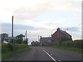
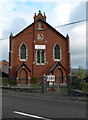
3
Capel y Green
Near the Tremeirchion junction at the Green, Denbigh
Image: © Eirian Evans
Taken: 8 Mar 2016
0.19 miles
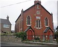
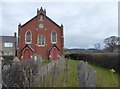
4
Capel Annibynwyr, y Green, Dinbych
Near the Tremeirchion junction at the Green, Denbigh
Image: © Eirian Evans
Taken: 9 Nov 2007
0.21 miles
5
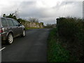
Bridge on the Tremeirchion Road, near The Green
A bridge over what used to be the railway.
Image: © Eirian Evans
Taken: 9 Nov 2007
0.24 miles