IMAGES TAKEN NEAR TO
Nantglyn, DENBIGH, LL16 5PP
Introduction
This page details the photographs taken nearby to LL16 5PP by members of the Geograph project.
The Geograph project started in 2005 with the aim of publishing, organising and preserving representative images for every square kilometre of Great Britain, Ireland and the Isle of Man.

There are currently over 7.5m images from over14,400 individuals and you can help contribute to the project by visiting https://www.geograph.org.uk
Image Map
Images are licensed for reuse under creativecommons.org/licenses/by-sa/2.0
Notes
- Clicking on the map will re-center to the selected point.
- The higher the marker number, the further away the image location is from the centre of the postcode.
Image Listing (13 Images Found)
Images are licensed for reuse under creativecommons.org/licenses/by-sa/2.0
Image
Details
Distance
1
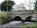
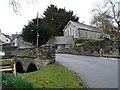
Nantglyn
Stone bridge running through the centre of the village
Image: © Dot Potter
Taken: 26 Mar 2006
0.14 miles
2
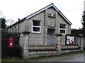
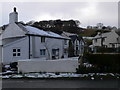
Nantglyn Church House
The church house in the village, built in 1922
Image: © Dot Potter
Taken: 26 Mar 2006
0.14 miles
3
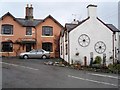
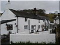
Nantglyn cottages
Colourful cottage within the village
Image: © Dot Potter
Taken: 26 Mar 2006
0.14 miles
5
Nantglyn
The village centre with the parish church of St. James seen over the bridge
Image: © Dot Potter
Taken: 26 Mar 2006
0.14 miles
7
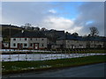
Council houses, Nantglyn
Behind the houses is the old primary school, which closed in the late 1990's.
Image: © Eirian Evans
Taken: 11 Feb 2009
0.20 miles
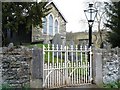
9
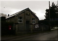
Church House, Nantglyn
Church hall, built in 1922, where many social events take place.
Image: © Eirian Evans
Taken: 11 Feb 2009
0.21 miles
10
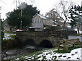
Nantglyn Bridge
Two-arched stone bridge in Nantglyn, with St Thomas' Church behind it.
Image: © Eirian Evans
Taken: 11 Feb 2009
0.21 miles