IMAGES TAKEN NEAR TO
Llansannan, DENBIGH, LL16 5NG
Introduction
This page details the photographs taken nearby to LL16 5NG by members of the Geograph project.
The Geograph project started in 2005 with the aim of publishing, organising and preserving representative images for every square kilometre of Great Britain, Ireland and the Isle of Man.

There are currently over 7.5m images from over14,400 individuals and you can help contribute to the project by visiting https://www.geograph.org.uk
Image Map
Images are licensed for reuse under creativecommons.org/licenses/by-sa/2.0
Notes
- Clicking on the map will re-center to the selected point.
- The higher the marker number, the further away the image location is from the centre of the postcode.
Image Listing (3 Images Found)
Images are licensed for reuse under creativecommons.org/licenses/by-sa/2.0
Image
Details
Distance
1
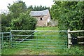
Gate and Outbuilding at Penrhos
This gate and outbuilding of Penrhos near Llansannan village is at grid reference SH 94852 64614.
Image: © Terry Hughes
Taken: 17 Aug 2006
0.02 miles
2
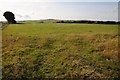
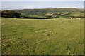
Farmland near Penrhos
Farmland near Penrhos to the south-east of Llansannan
Image: © Philip Halling
Taken: 14 Aug 2014
0.12 miles