IMAGES TAKEN NEAR TO
Llansannan, DENBIGH, LL16 5NE
Introduction
This page details the photographs taken nearby to LL16 5NE by members of the Geograph project.
The Geograph project started in 2005 with the aim of publishing, organising and preserving representative images for every square kilometre of Great Britain, Ireland and the Isle of Man.

There are currently over 7.5m images from over14,400 individuals and you can help contribute to the project by visiting https://www.geograph.org.uk
Image Map
Images are licensed for reuse under creativecommons.org/licenses/by-sa/2.0
Notes
- Clicking on the map will re-center to the selected point.
- The higher the marker number, the further away the image location is from the centre of the postcode.
Image Listing (4 Images Found)
Images are licensed for reuse under creativecommons.org/licenses/by-sa/2.0
Image
Details
Distance
1
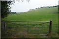
Gate to Field near Wern
This gate into a field is near Wern at grid reference SH 93873 63228.
Image: © Terry Hughes
Taken: 17 Aug 2006
0.12 miles
2
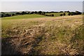
Farmland above the Afon Aled valley
Entrance to a field above the Afon Aled valley.
Image: © Philip Halling
Taken: 14 Aug 2014
0.17 miles
3
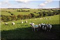
Sheep above Afon Hyrdd valley
Sheep in a field above the Afon Hyrdd valley.
Image: © Philip Halling
Taken: 14 Aug 2014
0.23 miles
4
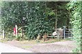
Post Box and Footpath at Rhyd Loew
This Post Box and footpath at Rhyd Loew is about three kilometres South of Llansannan at grid reference SH 93718 63378.
Image: © Terry Hughes
Taken: 17 Aug 2006
0.24 miles