IMAGES TAKEN NEAR TO
Llansannan, DENBIGH, LL16 5LB
Introduction
This page details the photographs taken nearby to LL16 5LB by members of the Geograph project.
The Geograph project started in 2005 with the aim of publishing, organising and preserving representative images for every square kilometre of Great Britain, Ireland and the Isle of Man.

There are currently over 7.5m images from over14,400 individuals and you can help contribute to the project by visiting https://www.geograph.org.uk
Image Map
Images are licensed for reuse under creativecommons.org/licenses/by-sa/2.0
Notes
- Clicking on the map will re-center to the selected point.
- The higher the marker number, the further away the image location is from the centre of the postcode.
Image Listing (2 Images Found)
Images are licensed for reuse under creativecommons.org/licenses/by-sa/2.0
Image
Details
Distance
1
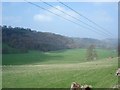
Farmland near Llansannan
The valley running from just outside Llansannan towards Bryn Rhyd yr Arian
Image: © Dot Potter
Taken: 21 Apr 2006
0.08 miles
2
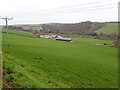
Plas Newydd Farm
In the valley of the River Aled, between Llansannan and Bryn-rhyd-yr-arian
Image: © Eirian Evans
Taken: 3 Jan 2019
0.18 miles