IMAGES TAKEN NEAR TO
Ffordd Meifod, DENBIGH, LL16 5AX
Introduction
This page details the photographs taken nearby to Ffordd Meifod, LL16 5AX by members of the Geograph project.
The Geograph project started in 2005 with the aim of publishing, organising and preserving representative images for every square kilometre of Great Britain, Ireland and the Isle of Man.

There are currently over 7.5m images from over14,400 individuals and you can help contribute to the project by visiting https://www.geograph.org.uk
Image Map
Images are licensed for reuse under creativecommons.org/licenses/by-sa/2.0
Notes
- Clicking on the map will re-center to the selected point.
- The higher the marker number, the further away the image location is from the centre of the postcode.
Image Listing (5 Images Found)
Images are licensed for reuse under creativecommons.org/licenses/by-sa/2.0
Image
Details
Distance
1
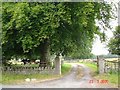
Stone walls leading to farm near Henllan
Stone walls and entrance to a farm near Henllan
Image: © Dot Potter
Taken: 23 Jul 2005
0.17 miles
2
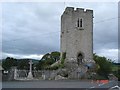
Henllan Parish Church Tower
The tower in front of the Parish church at Henllan
Image: © Dot Potter
Taken: 2 Aug 2005
0.17 miles
3
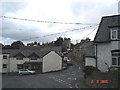
Henllan village
View across Church Road towards the church in Henllan
Image: © Dot Potter
Taken: 2 Aug 2005
0.17 miles
4
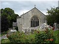
Henllan Parish Church
The Parish church in the village of Henllan
Image: © Dot Potter
Taken: 2 Aug 2005
0.17 miles
5
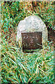
Old Milestone by the B5382, east of Henllan
Denbigh Plate by the B5382, in parish of Henllan (Denbighshire District), East of village, North side of road.
Inscription reads:-
Denbigh
2
Miles
Surveyed
Milestone Society National ID: DEN_DBLS02
Image: © Milestone Society
Taken: Unknown
0.24 miles