IMAGES TAKEN NEAR TO
Peniel, DENBIGH, LL16 4TS
Introduction
This page details the photographs taken nearby to LL16 4TS by members of the Geograph project.
The Geograph project started in 2005 with the aim of publishing, organising and preserving representative images for every square kilometre of Great Britain, Ireland and the Isle of Man.

There are currently over 7.5m images from over14,400 individuals and you can help contribute to the project by visiting https://www.geograph.org.uk
Image Map
Images are licensed for reuse under creativecommons.org/licenses/by-sa/2.0
Notes
- Clicking on the map will re-center to the selected point.
- The higher the marker number, the further away the image location is from the centre of the postcode.
Image Listing (2 Images Found)
Images are licensed for reuse under creativecommons.org/licenses/by-sa/2.0
Image
Details
Distance
1
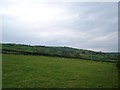
Prion Isa fields
Rolling fields leading to the hills at Prion Isa
Image: © Dot Potter
Taken: 6 May 2006
0.18 miles
2
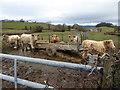
Supplementary feeding for steers
Young Charolais beef cattle at Prion Isa
Image: © Eirian Evans
Taken: 8 Mar 2016
0.22 miles