
IMAGES TAKEN NEAR TO
Peniel, DENBIGH, LL16 4TD
Introduction
This page details the photographs taken nearby to LL16 4TD by members of the Geograph project.
The Geograph project started in 2005 with the aim of publishing, organising and preserving representative images for every square kilometre of Great Britain, Ireland and the Isle of Man.

There are currently over 7.5m images from over14,400 individuals and you can help contribute to the project by visiting https://www.geograph.org.uk
Image Map
Images are licensed for reuse under creativecommons.org/licenses/by-sa/2.0
Notes
- Clicking on the map will re-center to the selected point.
- The higher the marker number, the further away the image location is from the centre of the postcode.
Image Listing (5 Images Found)
Images are licensed for reuse under creativecommons.org/licenses/by-sa/2.0
Image
Details
Distance
1
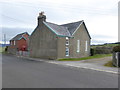
Peniel chapel and manse
Non-conformist mid-Victorian rural chapel founded in 1837 and rebuilt in its present form in 1866. The manse is attached.
Image: © Eirian Evans
Taken: 8 Mar 2016
0.02 miles
2
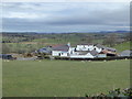
Garnedd Isa Farm, Peniel
Looking north west from the B4501 towards Garnedd Isa
Image: © Eirian Evans
Taken: 8 Mar 2016
0.07 miles
3
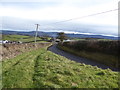
The B5401 heading northeast towards Peniel
The tiny hamlet consists of a chapel and a few houses.
Image: © Eirian Evans
Taken: 8 Mar 2016
0.09 miles
4
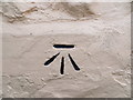
Ordnance Survey Cut Mark
This can be found on the wall of Aberglyniau - a private dwelling. The benmchmark height is recorded as being 178.485 metres above sea level.
For more detail see : https://www.bench-marks.org.uk/bm102461
Image: © Peter Wood
Taken: 23 Nov 2018
0.19 miles
5
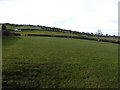
Peniel hillside
Looking south west towards Foel Gasyth
Image: © Eirian Evans
Taken: 8 Mar 2016
0.24 miles