IMAGES TAKEN NEAR TO
Llandyrnog, DENBIGH, LL16 4LR
Introduction
This page details the photographs taken nearby to LL16 4LR by members of the Geograph project.
The Geograph project started in 2005 with the aim of publishing, organising and preserving representative images for every square kilometre of Great Britain, Ireland and the Isle of Man.

There are currently over 7.5m images from over14,400 individuals and you can help contribute to the project by visiting https://www.geograph.org.uk
Image Map
Images are licensed for reuse under creativecommons.org/licenses/by-sa/2.0
Notes
- Clicking on the map will re-center to the selected point.
- The higher the marker number, the further away the image location is from the centre of the postcode.
Image Listing (6 Images Found)
Images are licensed for reuse under creativecommons.org/licenses/by-sa/2.0
Image
Details
Distance
1
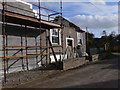
Ebenezer
Former chapel in Ffordd Las being converted into two houses.
Image: © Eirian Evans
Taken: 7 Nov 2008
0.03 miles
2
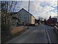
Dolwar
Formerly a chapel called Ebenezer, a Welsh Independent Chapel.
Image: © Eirian Evans
Taken: 28 Jan 2019
0.05 miles
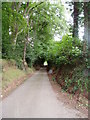
4
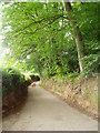
Country lane
The single track road is cut deep into the sandstone, and the beeches tower above.
Image: © Eirian Evans
Taken: 8 Jul 2006
0.19 miles
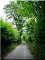
5
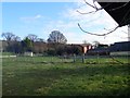
Road between Hendrerwydd and Rhiwbebyll
A single track road, cut deep into the sandstone, and the beeches tower above.
Image: © Eirian Evans
Taken: 8 Jul 2006
0.22 miles
6
Narrow road
The verges have recently been cut back leaving just enough room for the car to pass along the road.
Image: © Eirian Evans
Taken: 8 Jul 2006
0.24 miles