IMAGES TAKEN NEAR TO
Llandyrnog, DENBIGH, LL16 4LF
Introduction
This page details the photographs taken nearby to LL16 4LF by members of the Geograph project.
The Geograph project started in 2005 with the aim of publishing, organising and preserving representative images for every square kilometre of Great Britain, Ireland and the Isle of Man.

There are currently over 7.5m images from over14,400 individuals and you can help contribute to the project by visiting https://www.geograph.org.uk
Image Map
Images are licensed for reuse under creativecommons.org/licenses/by-sa/2.0
Notes
- Clicking on the map will re-center to the selected point.
- The higher the marker number, the further away the image location is from the centre of the postcode.
Image Listing (7 Images Found)
Images are licensed for reuse under creativecommons.org/licenses/by-sa/2.0
Image
Details
Distance
4
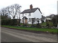
Delfryn
Victorian cottage opposite The Gables at Llanychan. The plaque above the door gives a date of 1862.
Image: © Eirian Evans
Taken: 19 Feb 2011
0.18 miles
6
Country cottage
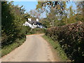
19th Century cottage On the Ruthin-Llandyrnog road.
Image: © Eirian Evans
Taken: 8 Jul 2006
0.19 miles
7
Cottage near Llanynys
In the process of being renovated.
Image: © Eirian Evans
Taken: 20 Oct 2007
0.20 miles