IMAGES TAKEN NEAR TO
Llandyrnog, DENBIGH, LL16 4HL
Introduction
This page details the photographs taken nearby to LL16 4HL by members of the Geograph project.
The Geograph project started in 2005 with the aim of publishing, organising and preserving representative images for every square kilometre of Great Britain, Ireland and the Isle of Man.

There are currently over 7.5m images from over14,400 individuals and you can help contribute to the project by visiting https://www.geograph.org.uk
Image Map
Images are licensed for reuse under creativecommons.org/licenses/by-sa/2.0
Notes
- Clicking on the map will re-center to the selected point.
- The higher the marker number, the further away the image location is from the centre of the postcode.
Image Listing (6 Images Found)
Images are licensed for reuse under creativecommons.org/licenses/by-sa/2.0
Image
Details
Distance
1
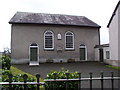
Capel y Dyffryn
Methodist chapel in Llandyrnog.
Image: © Eirian Evans
Taken: 11 Mar 2006
0.12 miles
2
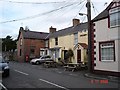
Llandyrnog
Village centre at Llandyrnog with the Golden Lion pub and empty shop to the centre of the photo
Image: © Dot Potter
Taken: 6 Nov 2005
0.17 miles
3
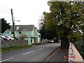
Approach to Llandyrnog
Main road into the village
Image: © Dot Potter
Taken: 6 Nov 2005
0.17 miles
4
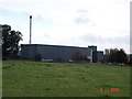
Llandyrnog creamery
The British Farmers creamery factory at Llandyrnog
Image: © Dot Potter
Taken: 6 Nov 2005
0.17 miles
5
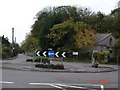
Waen roundabout
Roundabout on approach to Waen from Aberwheeler
Image: © Dot Potter
Taken: 6 Nov 2005
0.17 miles
6
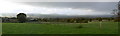
The Vale of Clwyd from Llangwyfan
Due west is Llandyrnog, and you can just make out the chimney of the Creamery.
Image: © Eirian Evans
Taken: 7 Nov 2008
0.22 miles