IMAGES TAKEN NEAR TO
Mold Road, DENBIGH, LL16 4DS
Introduction
This page details the photographs taken nearby to Mold Road, LL16 4DS by members of the Geograph project.
The Geograph project started in 2005 with the aim of publishing, organising and preserving representative images for every square kilometre of Great Britain, Ireland and the Isle of Man.

There are currently over 7.5m images from over14,400 individuals and you can help contribute to the project by visiting https://www.geograph.org.uk
Image Map
Images are licensed for reuse under creativecommons.org/licenses/by-sa/2.0
Notes
- Clicking on the map will re-center to the selected point.
- The higher the marker number, the further away the image location is from the centre of the postcode.
Image Listing (19 Images Found)
Images are licensed for reuse under creativecommons.org/licenses/by-sa/2.0
Image
Details
Distance
1
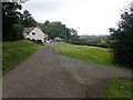
House in the hills
North-east of Bodfari
Image: © Eirian Evans
Taken: 22 Jul 2020
0.05 miles
2

Stile at the top of a steep hill, Bodfari
Image: © Mark Anderson
Taken: 5 May 2019
0.08 miles
3
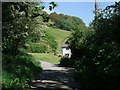
Maes-y-Graig, Bodfari
Offa's Dyke Path on the outskirts of Bodfari, starting the ascent of Moel-y-Gaer
Image: © Tim Heaton
Taken: 12 May 2009
0.09 miles
4
Offa's Dyke Path approaching Coed Moel-y-Gaer
Image: © Tim Heaton
Taken: 12 May 2009
0.11 miles
5
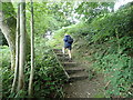
Hillside path
Offa's Dyke path on the slopes of Moel y Gaer
Image: © Eirian Evans
Taken: 22 Jul 2020
0.12 miles
6
Offa's Dyke Path
On the eastern slopes of Moel y Gaer
Image: © Eirian Evans
Taken: 22 Jul 2020
0.13 miles
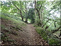
7
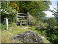
Stile on Moel-y-Gaer
Stile that gives the Offa's Dyke Path access into woodland that surrounds the ancient hill fort
Image: © Chris Heaton
Taken: 12 May 2009
0.13 miles
8
Offa's Dyke Footpath
Offa's Dyke footpath at Bodfari
Image: © Dot Potter
Taken: 25 Jul 2005
0.13 miles
9
Footbridge on Offa's Dyke
Wooden footbridge crossing the River Wheeler on the Offa's Dyke path
Image: © Dot Potter
Taken: 22 Jan 2006
0.13 miles
10

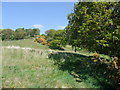
Tir amaethyddol islaw Moel y Gaer / Farmland below Moel y Gaer
Tir amaethyddol islaw Moel y Gaer gyda golygfa draw i Foel y Parc / Farmland below Moel y Gaer with a view over to Moel y Parc.
Image: © Ian Medcalf
Taken: 7 Apr 2010
0.18 miles