IMAGES TAKEN NEAR TO
Bodfari, DENBIGH, LL16 4BP
Introduction
This page details the photographs taken nearby to LL16 4BP by members of the Geograph project.
The Geograph project started in 2005 with the aim of publishing, organising and preserving representative images for every square kilometre of Great Britain, Ireland and the Isle of Man.

There are currently over 7.5m images from over14,400 individuals and you can help contribute to the project by visiting https://www.geograph.org.uk
Image Map
Images are licensed for reuse under creativecommons.org/licenses/by-sa/2.0
Notes
- Clicking on the map will re-center to the selected point.
- The higher the marker number, the further away the image location is from the centre of the postcode.
Image Listing (17 Images Found)
Images are licensed for reuse under creativecommons.org/licenses/by-sa/2.0
Image
Details
Distance
1
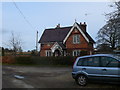
Pontruffydd Lodge
Another view of the lodge to Pontruffydd Hall.
Image: © Eirian Evans
Taken: 8 Feb 2009
0.04 miles
4
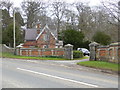
Lodge to Pontruffydd Hall Farm
Ornate entrance lodge to Pontruffydd Hall
Image: © Eirian Evans
Taken: 8 Mar 2016
0.06 miles

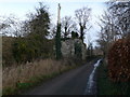
6
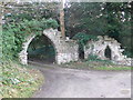
Gothic arch, Pontruffydd Hall
Pontruffydd Hall, one of a number of larger halls in the Bodfari area, was formerly a 16th-century structure, but this was replaced by a gothic-style rendered house in the 19th century, together with this gothic arch at the entrance to the estate.
Image: © Eirian Evans
Taken: 8 Feb 2009
0.09 miles
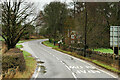
7

Pontruffydd Lodge
A lodge to Pontruffydd Hall, on the Bodfari to Denbigh road.
Image: © Eirian Evans
Taken: 8 Feb 2009
0.12 miles


10
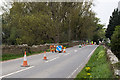
North Wales WWII defences: Pont Ruffydd, Bodfari - pillbox remains (1)
Remains of a pillbox built into a wall on the east side of the bridge over the River Clwyd near Bodfari. On this side of the wall is the pillbox base that projects outwards from the wall seen between the first pair of cones. Part of the Clwydian Range Stop Line from Mostyn in the north, to Llangollen in the south.
Image
Image: © Mike Searle
Taken: 10 May 2016
0.17 miles