IMAGES TAKEN NEAR TO
Bryn Dedwydd, DENBIGH, LL16 3TW
Introduction
This page details the photographs taken nearby to Bryn Dedwydd, LL16 3TW by members of the Geograph project.
The Geograph project started in 2005 with the aim of publishing, organising and preserving representative images for every square kilometre of Great Britain, Ireland and the Isle of Man.

There are currently over 7.5m images from over14,400 individuals and you can help contribute to the project by visiting https://www.geograph.org.uk
Image Map
Images are licensed for reuse under creativecommons.org/licenses/by-sa/2.0
Notes
- Clicking on the map will re-center to the selected point.
- The higher the marker number, the further away the image location is from the centre of the postcode.
Image Listing (242 Images Found)
Images are licensed for reuse under creativecommons.org/licenses/by-sa/2.0
Image
Details
Distance
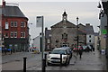
1
St Mary's church in Denbigh on a wet night
Image: © Roger Davies
Taken: 25 Apr 2014
0.06 miles

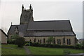
9
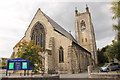
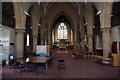
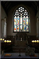
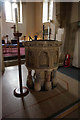
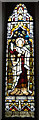
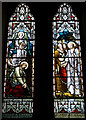
St Mary's Church, Denbigh
St Mary’s in Denbigh is a Victorian church built in 1875.
Image: © Jeff Buck
Taken: 9 Oct 2015
0.06 miles