IMAGES TAKEN NEAR TO
High Street, DENBIGH, LL16 3LB
Introduction
This page details the photographs taken nearby to High Street, LL16 3LB by members of the Geograph project.
The Geograph project started in 2005 with the aim of publishing, organising and preserving representative images for every square kilometre of Great Britain, Ireland and the Isle of Man.

There are currently over 7.5m images from over14,400 individuals and you can help contribute to the project by visiting https://www.geograph.org.uk
Image Map
Images are licensed for reuse under creativecommons.org/licenses/by-sa/2.0
Notes
- Clicking on the map will re-center to the selected point.
- The higher the marker number, the further away the image location is from the centre of the postcode.
Image Listing (309 Images Found)
Images are licensed for reuse under creativecommons.org/licenses/by-sa/2.0
Image
Details
Distance
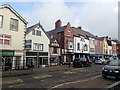
1
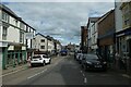
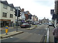
High Street, Denbigh
Looking along the High Street from the junction with Portland Place.
Image: © DS Pugh
Taken: 7 Aug 2020
0.01 miles
2
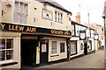
The Golden Lion and The White Lion, Denbigh
The Golden Lion is thought to date from the 16th century. It was originally two adjacent properties until a pub landlord took over the adjacent shop, then used by a jeweller, to expand his business. Back Row contains some of the oldest buildings in Denbigh not connected with the castle or town walls.
*Source: historypoints.org
Image: © Jeff Buck
Taken: 9 Oct 2015
0.01 miles
3
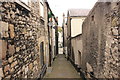
Denbigh Alleyway
Narrow alleyway heading towards the high street.
Image: © Jeff Buck
Taken: 9 Oct 2015
0.02 miles
4
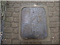
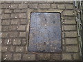
Decorative manhole cover, Broomhill Lane
One of seven decorative manhole covers which are installed in a narrow passage that leads to Denbigh Castle, each cover has a different illustration showing the history of the town. They were designed by Rebecca Gouldson. Two more are shown here Image and Image - the other four were snow-covered! This cover represents the glove-making industry
Image: © Eirian Evans
Taken: 5 Mar 2018
0.02 miles
5
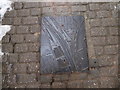
Decorative manhole cover, Broomhill Lane
One of seven decorative manhole covers which are installed in a narrow passage that leads to Denbigh Castle, each cover has a different illustration showing the history of the town. They were designed by Rebecca Gouldson. Two more are shown here Image and Image - the other four were snow-covered! This cover represents Kate Roberts (1891–1985), author and also a link with Gwasg Gee
Image: © Eirian Evans
Taken: 5 Mar 2018
0.02 miles
6
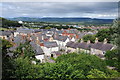
The rooftops of Denbigh
View across the rooftops of the town of Denbigh. The Clwydian Hills can be seen in the background.
Image: © Philip Halling
Taken: 30 Aug 2013
0.02 miles
7
Decorative manhole cover, Broomhill Lane
One of seven decorative manhole covers which are installed in a narrow passage that leads to Denbigh Castle, each cover has a different illustration showing the history of the town. They were designed by Rebecca Gouldson. Two more are shown here Image and Image - the other four were snow-covered! This cover represents the Denbigh, Ruthin and Corwen Railway, and the opening of the railway from Ruthin to Denbigh on St David's day 1862
Image: © Eirian Evans
Taken: 5 Mar 2018
0.02 miles
8
In Denbigh
Outside The Old Vaults, Public House.
Image: © Michael Graham
Taken: 26 Sep 2013
0.02 miles
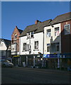
9
Shops on the High Street, Denbigh
Timbers from the half-timbered building, Siop Clwyd, has been dated by dendrochronology to 1533, indicating it was built very close to this date. This would make it the earliest dated domestic building in the town.
Image: © Eirian Evans
Taken: 11 Feb 2019
0.02 miles
10
Denbigh town centre
Arcaded shops on Denbigh town square. The ground floors of the shops are below the level of the road.
Image: © Eirian Evans
Taken: 24 Jan 2008
0.02 miles