IMAGES TAKEN NEAR TO
Ruthin Road, DENBIGH, LL16 3EL
Introduction
This page details the photographs taken nearby to Ruthin Road, LL16 3EL by members of the Geograph project.
The Geograph project started in 2005 with the aim of publishing, organising and preserving representative images for every square kilometre of Great Britain, Ireland and the Isle of Man.

There are currently over 7.5m images from over14,400 individuals and you can help contribute to the project by visiting https://www.geograph.org.uk
Image Map
Images are licensed for reuse under creativecommons.org/licenses/by-sa/2.0
Notes
- Clicking on the map will re-center to the selected point.
- The higher the marker number, the further away the image location is from the centre of the postcode.
Image Listing (39 Images Found)
Images are licensed for reuse under creativecommons.org/licenses/by-sa/2.0
Image
Details
Distance
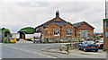
1
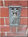
Ordnance Survey Pivot
This OS pivot can be found on the ledge of the gatepost at the entrance to the Hospital on Park Street. It marks a point 54.270m above mean sea level.
Image: © Adrian Dust
Taken: 9 Aug 2015
0.02 miles
2
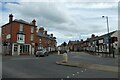
Ruthin Road
Looking along Ruthin Road from the bottom of Vale Street in Denbigh.
Image: © DS Pugh
Taken: 7 Aug 2020
0.03 miles
3
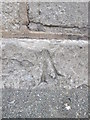
Flush Bracket G2920 on Ruthin Road, Denbigh
For more details see: https://www.bench-marks.org.uk/bm14859
Image: © Meirion
Taken: 12 Sep 2019
0.04 miles
4
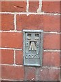
Ordnance Survey Flush Bracket (G2920)
This OS Flush Bracket can be found on the north face of No1 Ruthin Road. It marks a point 55.038m above mean sea level.
Image: © Adrian Dust
Taken: 9 Aug 2015
0.04 miles
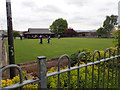
5

Denbigh
End of Vale Street.
The remains of the railway line bridge is the left wall.
Denbigh was a terminal station of the Vale of Clwyd Railway opened in 1858.
https://en.wikipedia.org/wiki/Vale_of_Clwyd_Railway
The railway line here was a continuation of the line by the Denbigh, Ruthin and Corew Railway that opened in 1862 and completed in 1865.
https://en.wikipedia.org/wiki/Denbigh%2C_Ruthin_and_Corwen_Railway
Image: © James Emmans
Taken: 21 Aug 2019
0.05 miles
6
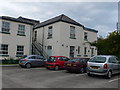
Denbigh Infirmary
Denbighshire Infirmary was founded in 1807 and was the first institution of its kind in North Wales. In the early years it was known as “Denbigh General Dispensary and Asylum for the Recovery of Health”.
Image: © Eirian Evans
Taken: 21 Sep 2010
0.05 miles
8
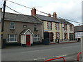
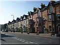
Terrace on Rhyl Road, Denbigh
On the left is "Yr Hen Dafarn" (the Old Tavern) which was renovated in 1983 and beside it is Southsea Terrace.
Image: © Eirian Evans
Taken: 27 Feb 2008
0.06 miles
9
Denbigh station (remains), 1993
View northward from the A525, towards Mold and Chester: ex-LNWR line from Chester, which continued south to Ruthin and Corwen, also there was a branch from Rhyl. The station was closed to passengers 30/4/62, when the service Chester - Ruthin ceased (Ruthin - Corwen ceased 2/2/53), but goods continued to Denbigh from Rhyl until 1/1/68 although the passenger service from Rhyl had ceased from 19/9/55.
Image: © Ben Brooksbank
Taken: 17 Jun 1993
0.06 miles