IMAGES TAKEN NEAR TO
Ruthin Road, DENBIGH, LL16 3EB
Introduction
This page details the photographs taken nearby to Ruthin Road, LL16 3EB by members of the Geograph project.
The Geograph project started in 2005 with the aim of publishing, organising and preserving representative images for every square kilometre of Great Britain, Ireland and the Isle of Man.

There are currently over 7.5m images from over14,400 individuals and you can help contribute to the project by visiting https://www.geograph.org.uk
Image Map
Images are licensed for reuse under creativecommons.org/licenses/by-sa/2.0
Notes
- Clicking on the map will re-center to the selected point.
- The higher the marker number, the further away the image location is from the centre of the postcode.
Image Listing (19 Images Found)
Images are licensed for reuse under creativecommons.org/licenses/by-sa/2.0
Image
Details
Distance
2
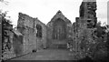
Friary Church, Denbigh
View from west in 1980.
Image: © Sandy Gerrard
Taken: Unknown
0.12 miles
3
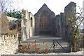
Denbigh Friary
These remains date from about 1300 and were part of the Church of the Friary of Carmelites (White Friars).
Image: © Stephen McKay
Taken: 7 Mar 2011
0.13 miles
5
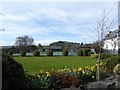
Denbigh Tennis Club
Adjacent to Denbigh High School on Ruthin Road.
Image: © Eirian Evans
Taken: 12 Apr 2016
0.14 miles
6
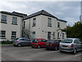
Denbigh Infirmary
Denbighshire Infirmary was founded in 1807 and was the first institution of its kind in North Wales. In the early years it was known as “Denbigh General Dispensary and Asylum for the Recovery of Health”.
Image: © Eirian Evans
Taken: 21 Sep 2010
0.15 miles
7
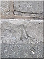
Ordnance Survey Pivot
This OS pivot can be found on the ledge of the gatepost at the entrance to the Hospital on Park Street. It marks a point 54.270m above mean sea level.
Image: © Adrian Dust
Taken: 9 Aug 2015
0.16 miles
8
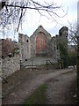
Denbigh Friary
This building is part of the church of the Carmelite Friary in Denbigh, which was probably founded by Sir John Salusbury of Lleweni about 1289. The remains date from about 1300.
Image: © Eirian Evans
Taken: 27 Feb 2008
0.17 miles
9
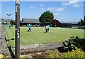
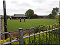
Match in progress
At Denbigh Bowling Green
Image: © Eirian Evans
Taken: 6 Jun 2018
0.17 miles
10
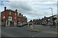
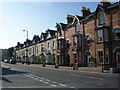
Ruthin Road
Looking along Ruthin Road from the bottom of Vale Street in Denbigh.
Image: © DS Pugh
Taken: 7 Aug 2020
0.19 miles