IMAGES TAKEN NEAR TO
Llanfair Dyffryn Clwyd, RUTHIN, LL15 2SN
Introduction
This page details the photographs taken nearby to LL15 2SN by members of the Geograph project.
The Geograph project started in 2005 with the aim of publishing, organising and preserving representative images for every square kilometre of Great Britain, Ireland and the Isle of Man.

There are currently over 7.5m images from over14,400 individuals and you can help contribute to the project by visiting https://www.geograph.org.uk
Image Map
Images are licensed for reuse under creativecommons.org/licenses/by-sa/2.0
Notes
- Clicking on the map will re-center to the selected point.
- The higher the marker number, the further away the image location is from the centre of the postcode.
Image Listing (7 Images Found)
Images are licensed for reuse under creativecommons.org/licenses/by-sa/2.0
Image
Details
Distance
2
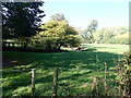
Afon Hesbin
Winding its way to the River Clwyd from Llanelidan
Image: © Eirian Evans
Taken: 10 Oct 2018
0.18 miles
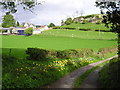
4
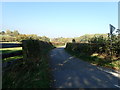
Country lane near Rhyd-y-Meudwy
Heading towards Graigadwywynt
Image: © Eirian Evans
Taken: 10 Oct 2018
0.23 miles
5
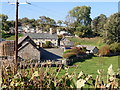
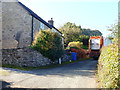
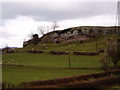
Ty Brith, Pentrecelyn
Sheltered by a limestone escarpment. No longer farming but supplying beekeeping equipment.
Image: © Eirian Evans
Taken: 10 Oct 2018
0.23 miles
7
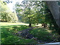
Afon Hesbin
Hardly a trickle of water in the stream today
Image: © Eirian Evans
Taken: 10 Oct 2018
0.25 miles