IMAGES TAKEN NEAR TO
Llanfair Dyffryn Clwyd, RUTHIN, LL15 2SH
Introduction
This page details the photographs taken nearby to LL15 2SH by members of the Geograph project.
The Geograph project started in 2005 with the aim of publishing, organising and preserving representative images for every square kilometre of Great Britain, Ireland and the Isle of Man.

There are currently over 7.5m images from over14,400 individuals and you can help contribute to the project by visiting https://www.geograph.org.uk
Image Map
Images are licensed for reuse under creativecommons.org/licenses/by-sa/2.0
Notes
- Clicking on the map will re-center to the selected point.
- The higher the marker number, the further away the image location is from the centre of the postcode.
Image Listing (8 Images Found)
Images are licensed for reuse under creativecommons.org/licenses/by-sa/2.0
Image
Details
Distance
1
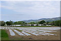
Field of Maize
The maize has been planted through the plastic, which keeps down the weeds and provides a greenhouse effect for the maize. From afar they look like lakes.
Image: © Eirian Evans
Taken: 4 Jun 2005
0.05 miles
2
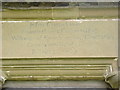
Inscription, Capel y Gloch
Above the door of Jesus Chapel which states that the church was founded and endowed by Rice Williams in 1619.
Image: © Eirian Evans
Taken: 4 Jun 2005
0.13 miles
3
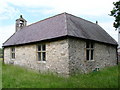
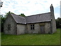
Jesus Chapel, Llanfair D.C.
Also known as Capel y Gloch.
Image: © Eirian Evans
Taken: 4 Jun 2005
0.13 miles
4
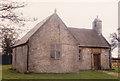
Jesus Chapel
The original timber chapel was built in 1619. This stone replacement dates from 1787.
Image: © Jonathan Thacker
Taken: 18 Apr 1987
0.13 miles
5
Capel y Gloch
A tiny "office" chapel, hidden just off the A525 near Pentrecelyn. The plaque above the door reads "Jesus Chapel was Founded and Endowed by Rice Williams of Eyarth ucha, Gent 1619. Consecrated 1623. Rebuilt 1787".
Image: © Eirian Evans
Taken: 4 Jun 2005
0.15 miles
6
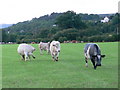
Cattle in a field near Pentrecelyn
The houses on the hill are in Graigfechan.
Image: © Eirian Evans
Taken: 6 Aug 2007
0.15 miles
7
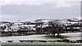
Snow-covered Fields and Hills near Pentre-Celyn
Image: © David Dixon
Taken: 23 Jan 2019
0.19 miles
8
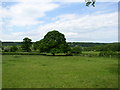
Llanbenwch farmland
West of the A525 near Pentrecelyn
Image: © Eirian Evans
Taken: 4 Jun 2005
0.21 miles