IMAGES TAKEN NEAR TO
Clawddnewydd, RUTHIN, LL15 2NN
Introduction
This page details the photographs taken nearby to LL15 2NN by members of the Geograph project.
The Geograph project started in 2005 with the aim of publishing, organising and preserving representative images for every square kilometre of Great Britain, Ireland and the Isle of Man.

There are currently over 7.5m images from over14,400 individuals and you can help contribute to the project by visiting https://www.geograph.org.uk
Image Map (Loading...)


Getting Data...Please wait
Leaflet Map data © OpenStreetMap
Images are licensed for reuse under creativecommons.org/licenses/by-sa/2.0
Notes
- Clicking on the map will re-center to the selected point.
- The higher the marker number, the further away the image location is from the centre of the postcode.
Image Listing (3 Images Found)
Images are licensed for reuse under creativecommons.org/licenses/by-sa/2.0
Image
Details
Distance
1
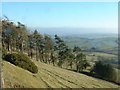
Vale of Clwyd
Looking south east, from the B5105
Image: © David Medcalf
Taken: 30 Jan 2006
0.10 miles
2
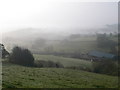
Vale of Clwyd in the mist
Looking towards the Vale of Clwyd from the B5105 west of Clawddnewydd, shrouded in mist this Spring morning.
Image: © Eirian Evans
Taken: 3 Apr 2009
0.18 miles
3
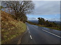
The B5105
Heading east on the Cerrig-y-Drudion to Ruthin Road. Clwydian hills in the distance.
Image: © Eirian Evans
Taken: 16 Mar 2018
0.22 miles