IMAGES TAKEN NEAR TO
Pentre Celyn, RUTHIN, LL15 2HF
Introduction
This page details the photographs taken nearby to LL15 2HF by members of the Geograph project.
The Geograph project started in 2005 with the aim of publishing, organising and preserving representative images for every square kilometre of Great Britain, Ireland and the Isle of Man.

There are currently over 7.5m images from over14,400 individuals and you can help contribute to the project by visiting https://www.geograph.org.uk
Image Map (Loading...)


Getting Data...Please wait
Leaflet Map data © OpenStreetMap
Images are licensed for reuse under creativecommons.org/licenses/by-sa/2.0
Notes
- Clicking on the map will re-center to the selected point.
- The higher the marker number, the further away the image location is from the centre of the postcode.
Image Listing (6 Images Found)
Images are licensed for reuse under creativecommons.org/licenses/by-sa/2.0
Image
Details
Distance
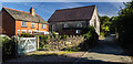
1
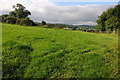
Field at Pentre-Celyn
Field at Pentre-Celyn on the edge of the village of Pentre-Celyn.
Image: © Philip Halling
Taken: 30 Aug 2013
0.01 miles
2
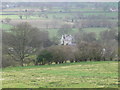
Pentrecelyn Hall
As seen from the "top road", Graigfechan to Llandegla. A neo-Tudor villa, dated 1852.
Image: © Eirian Evans
Taken: 6 Apr 2008
0.12 miles
3
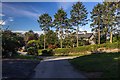
Ysgol Pentrecelyn
Welsh medium primary school at Pentrecelyn
Image: © Eirian Evans
Taken: 10 Oct 2018
0.17 miles
5

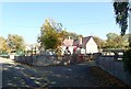
Chapel in Pentre-Celyn
Methodist chapel in the village of Pentre-Celyn.
Image: © Philip Halling
Taken: 30 Aug 2013
0.19 miles