IMAGES TAKEN NEAR TO
Bontuchel, RUTHIN, LL15 2DG
Introduction
This page details the photographs taken nearby to LL15 2DG by members of the Geograph project.
The Geograph project started in 2005 with the aim of publishing, organising and preserving representative images for every square kilometre of Great Britain, Ireland and the Isle of Man.

There are currently over 7.5m images from over14,400 individuals and you can help contribute to the project by visiting https://www.geograph.org.uk
Image Map
Images are licensed for reuse under creativecommons.org/licenses/by-sa/2.0
Notes
- Clicking on the map will re-center to the selected point.
- The higher the marker number, the further away the image location is from the centre of the postcode.
Image Listing (5 Images Found)
Images are licensed for reuse under creativecommons.org/licenses/by-sa/2.0
Image
Details
Distance
1
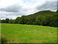
Grazing field and woodland strip near Derwen-fawr
The woodland seen to the rear on the right is Coed Felin-y-moch woodland and lies on the northern side of the Afon Clywedog, hidden in a valley between.
Image: © Maggie Cox
Taken: 16 Aug 2015
0.10 miles
2
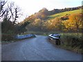
Yr Hen Felin
Travelling west from Bontuchel towards Cyffylliog, the road forks to the left (out of shot) or to the right over the bridge and thence past Yr Hen Felin. Even at two o'clock in the afternoon, the November sunshine has not reached into the valley to melt the frost still clinging to the bridge parapets.
Image: © Roger May
Taken: 21 Nov 2005
0.11 miles
3
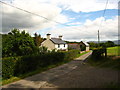
Minor lane leading to Bontuchel
Derwen Fawr Farm on the left
Image: © Maggie Cox
Taken: 16 Aug 2015
0.16 miles
4
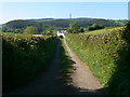
Bryn Ffynnon
Farm road leading to bryn Ffynnon, west of Bontuchel.The Clocaenog Forest can be seen on the Hiraethog mountains beyond the farm.
Image: © Eirian Evans
Taken: 14 May 2008
0.17 miles
5
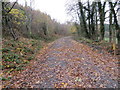
Woodland track at Coed Tre'r-parc
Looking south-westward.
Image: © Peter Wood
Taken: 19 Nov 2018
0.21 miles