IMAGES TAKEN NEAR TO
Cyffylliog, RUTHIN, LL15 2BU
Introduction
This page details the photographs taken nearby to LL15 2BU by members of the Geograph project.
The Geograph project started in 2005 with the aim of publishing, organising and preserving representative images for every square kilometre of Great Britain, Ireland and the Isle of Man.

There are currently over 7.5m images from over14,400 individuals and you can help contribute to the project by visiting https://www.geograph.org.uk
Image Map
Images are licensed for reuse under creativecommons.org/licenses/by-sa/2.0
Notes
- Clicking on the map will re-center to the selected point.
- The higher the marker number, the further away the image location is from the centre of the postcode.
Image Listing (3 Images Found)
Images are licensed for reuse under creativecommons.org/licenses/by-sa/2.0
Image
Details
Distance
1
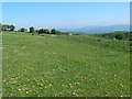
High paddock with a view
The whole of the Vale of Clwyd can be seen from here, all the way to the Irish Sea.
Image: © Eirian Evans
Taken: 14 May 2008
0.07 miles
2
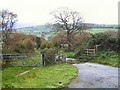
Cattle Grid by Rabbit Warren Hill
The lane from Sceibion Bach in the middle distance climbs to this point, where a cattle grid keeps the sheep grazing on Rabbit Warren Hill (behind shot) from straying away.
Image: © Roger May
Taken: 21 Nov 2005
0.11 miles
3
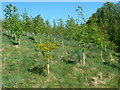
Young woodland, Hiraethog hills
Young oaks, rowan, ash, coming along nicely.
Image: © Eirian Evans
Taken: 14 May 2008
0.20 miles