IMAGES TAKEN NEAR TO
Clocaenog, RUTHIN, LL15 2AY
Introduction
This page details the photographs taken nearby to LL15 2AY by members of the Geograph project.
The Geograph project started in 2005 with the aim of publishing, organising and preserving representative images for every square kilometre of Great Britain, Ireland and the Isle of Man.

There are currently over 7.5m images from over14,400 individuals and you can help contribute to the project by visiting https://www.geograph.org.uk
Image Map (Loading...)


Getting Data...Please wait
Leaflet Map data © OpenStreetMap
Images are licensed for reuse under creativecommons.org/licenses/by-sa/2.0
Notes
- Clicking on the map will re-center to the selected point.
- The higher the marker number, the further away the image location is from the centre of the postcode.
Image Listing (10 Images Found)
Images are licensed for reuse under creativecommons.org/licenses/by-sa/2.0
Image
Details
Distance
1
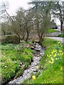
Nant y Cefn, at Clocaenog
Nant y Cefn is a stream which feeds into Nant Meindwr, a tributary of the River Clywedog. The stream runs close to the village school.
Image: © Eirian Evans
Taken: 22 Apr 2006
0.04 miles
2
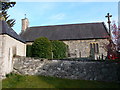
Clocaenog Church
Dedicated to St Trillo. https://cpat.org.uk/Archive/churches/denbigh/16749.htm
Image: © Eirian Evans
Taken: 6 Apr 2007
0.06 miles
3
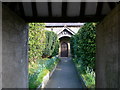
St Trillo's Church, Clocaenog
Looking along the path to the church porch.
Image: © Eirian Evans
Taken: 6 Apr 2007
0.06 miles
4

Churchyard, Clocaenog
The yew in the churchyard at St Trillo's, Clocaenog.
Image: © Eirian Evans
Taken: 6 Apr 2007
0.06 miles
5
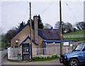
Ysgol Clocaenog.
Ysgol Clocaenog is a small rural school situated in the village of Clocaenog in the Vale of Clwyd. Children come here from the villages of Clocaenog, Clawdd Newydd, Derwen and the surrounding areas.
Image: © Eirian Evans
Taken: 22 Apr 2006
0.08 miles
6
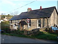
Capel Bethesda
Built in 1835, this is a small Wesleyan chapel in Clocaenog.
Image: © Eirian Evans
Taken: 6 Apr 2007
0.08 miles
7
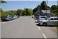
Clocaenog
Cars parked in the centre of Clocaenog near the village school.
Image: © Philip Halling
Taken: 11 Jun 2015
0.08 miles
8
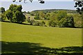
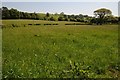
Farmland at Clocaenog
Farmland at Clocaenog, Coed y Fron a wooded hill can be seen in the background.
Image: © Philip Halling
Taken: 11 Jun 2015
0.20 miles
9
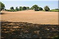
Bare field
The grass in this field appears to have been sprayed ready for arable use.
Image: © Philip Halling
Taken: 11 Jun 2015
0.21 miles